 Intelligence gathering is as old as human civilization. Good Intelligence generally leads to success, whereas failure to gather timely Intelligence has invariably resulted in defeat and ruin. Gathering Intelligence is not easy. The trouble about Intelligence collection was aptly stated by US Vice President Dick Cheney. He stated, “We know what we know; we know what we don’t know; we don’t know what we don’t know.”
The last is most dangerous, yet many a people—laymen as well as experts—how some seem to have implicit faith in the ability to obtain complete information on our adversaries. This unfortunately is not correct.
It is one thing to wish for all the necessary information, well in time, to suit or design our strategy. Reality is often different. When chips are down and the selected strategy fails, the blame invariably is on faulty Intelligence input. Blaming poor Intelligence in hindsight helps no one, least of all in mourning the dead and trying to recover the losses.
…the constellation of eleven operational civil imaging satellites currently makes India one with the largest in satellite imaging. The others being USA, Russia, Canada, France, Israel and Japan.
Rather, the planner must take into account the likely Intelligence and thus modify the strategy to suit the limits of Intelligence.
Satellite Imagery
Satellites today contribute towards intelligence gathering quite a lot. Unlike other agents of intelligence collection, satellites can fly over entire planet. There are no national boundaries in space. India is one of the privileged members of exclusive club of nations with its own Imaging satellite capability. In fact the constellation of eleven operational civil imaging satellites currently makes India one with the largest in satellite imaging. The others being USA, Russia, Canada, France, Israel and Japan. China and Brazil also are making inroads into sophisticated levels of satellite imaging.
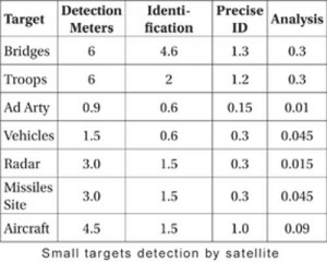
In pure commercial terms, Indian IRS-IC and ID satellites at one time had the best resolution of 5.8 meter in Panchromatic Field. To summarize, today, India has a capability better than one meter resolution from panchromatic cameras. It also has stereoscopic performance. It can revisit a target every day. India plans to achieve resolution of 30 cm with launch of Cartosat by 2013. All this seems extremely promising and exciting to a layman. But a look at the table below will make it clear that for small targets detection and identification by satellite we are still a far way off.
 Michael O’Hanlon, a senior fellow in Foreign Policy Studies at Brookings Institutions and a specialist in US defence strategy, defence budget, military technology etc has authored a book titled “Technological change and the Future of Warfare” published in early 2000. Looking at future vis-à-vis USA’s advances in technology he states, “It is quite unlikely that in 2020 infantry soldiers holding man-portable anti tank weapons would be spotted by satellite, aircraft or UAV. They could generally stay completely out of view in foxholes until US Forces approached, particularly if foliage or buildings provided cover. In many cases they would be able to ambush U.S. forces.”1
This is because the density of troops on battlefield is constantly reducing. “In antiquity roughly 500 soldiers filled up the battlefield space equivalent in size to one Football field; in American civil war twenty took up that space; in World War I, just two did. In World War II, a single soldier occupied roughly fire foot ball fields, and, according to 1980s NATO doctrine, one soldier would have had ten football fields to himself”. 2 In guerilla warfare this dispersion is even more.
Why would a satellite have a problem in identifying dispersed individuals? Imagery satellites normally orbit between 500 and 1000 km. If lower in orbit their life reduces due to constant drag, no matter how small. If the satellite is moved higher then the same cameras resolution becomes poorer and it has difficulty identifying small objects which it could from lower orbit. The camera on board satellite has certain focal length, which means the scale of photography is fixed. Scale means that one centimeter on photograph will represent certain centimeters on ground which could vary between 5000 and 50000 cm depending upon the focal length. Thus lower the orbit, smaller items can be seen or a large scale is possible.
Scale relates to the size of the object we want to photograph. Whereas in normal photography we mostly photograph the vertical dimension, in photography from space and air it is mostly the plan dimension as seen by cameras passing over the target. This means an individual when photographed will be represented by the top view of his head and shoulders. This means a large reduction in the size of man leading to difficulty in identifying the image as that of a human being. Of course, the man’s shadow if captured nicely will help. But for that we need to photograph from an angle and when sun is around 45 degrees from horizon. This reduces the resolution!
This is not all. There is one more important limitation. The image is stored on a film or negative or better still an electronic screen. Now all these recording mediums are composed of either chemical material or pixels, i.e. the medium comprises many small particles on each of which a part of image will be stored. The size of these particles or grains (in a film negative) or pixel in an electronic screen can record image of only a certain size. This is called Resolution. Say the Resolution is 5 meters.
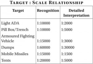 Even if the object being photographed is small say one meter in size, it is recorded on a small grain or pixel which represents 5 meters on ground. So this recording can not recognize one meter object. For object to be spotted it must be minimum 5 meters in size. And to be identified as such about four times the resolution i.e. 20 meters in size in this case.
The best resolution from satellites currently is not sufficient to identify individual human beings. And we are at the moment talking of humans without disguise. Therefore, satellites have lots of difficulty in identifying individual terrorists. To be able to do so we would probably need resolution of few centimeters. Following tables give some idea of what can be seen and identified from aerial photographs or satellite photographs.
Resolution vs Object Size
SPOT a French satellite had a black and white resolution of 10 metres and Multispectral resolution in four bands of 20 meters. This was sufficient for :
- Detection of Objects - 10–30 m in size
- Recognition of objects - 20–60 m in size
- Description of objects - 60 m or more
USA is a leading country in the art and science of photo intelligence. Its KH-11 satellite has a resolution of 15 centimeters. Its UAVs flying at 1-kilometer height can record objects 1 centimeter in size. It’s Infra Red sensors can make Image of aircraft or tank.3 Yet USAF’s claim of — find, fix and track targets — is true only for recognizable military objects. It is unlikely to detect decoys, enemy soldiers interspersed among a background population or in heavy forests; mortars and anti tank and anti-aircraft missiles hidden in trucks or caves and properly secured weapons of mass destruction.4 KH-12 the more advanced imaging satellite has a resolution less than 3 inches, probably when it is maneuvered into a lower orbit.5
 The day light camera on board a satellite will not be able to record if targets are masked by cloud cover, mist, fog, dust haze, shadow and camouflage. If on the other hand satellite has an Infra Red Sensor then it will be possible to record during night but clarity of recordings at satellites orbital heights will be questionable. Also there will be no shadow of objects, so helpful during interpretation. Even electro-optical devices like a low light Television camera or Image intensifiers will have difficulties onboard a satellite.
The next misperception is that a satellite in space can watch over targets 24 hours a day—all over India. Reality is different. This could be true for a Geo Stationary satellite, which at an orbit of 36090 km remains fixed in relation to a position on Earth. In reality both the satellite and Earth are rotating at about 3000 miles per hour from west to east. But such satellites are used for mostly communication. This orbit is far too high for an imaging satellite. Imaging satellites orbit around 500-1000 km above Earth.
To be able to photograph at a good light condition i.e. when Sun is about 9 `O’ clock to 10 `O’ clock and shadows are present, these satellites are programmed to photograph at this time. Shadows help in object identification revealing its vertical dimension. Subsequent photographs on satellites revisit enable photo comparison with previous photos to detect changes. For this arrangement Imaging satellites are put on a polar orbit and their orbit is synchronized with the Sun angle.
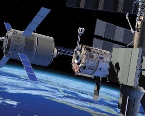 Polar orbit sun synchronous satellites trajectory on ground traces a path over different place in each subsequent orbit. While the satellite goes around in Polar Sun Synchronous orbit, usually taking about 80-100 minutes for each orbit, the Earth down below continues to rotate from West to East. So on subsequent orbits, the cameras on satellite face a new portion of Earth. The rest of the Earth is away from the prying eyes of the camera at that moment. When the same piece of ground is seen by camera again, it is called `Revisit’. Revisit time varies for various satellites. It could vary between 3-25 days, a result of many factors. Sufficient for us to remember that there are large gaps in satellite surveillance.6
There are many other peculiarities associated with receiving the data from satellite, formatting it, printing the data in a photo format, analyzing the information and finally dispatching the same to the end user. All this takes time. Following para will give an approximate idea of the time cycle involved.7
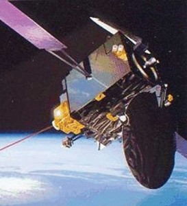 As the satellite passes over an area its camera record the scene. In the 60s and 70s the recording used to be done on a photographic negative. The negative housed in a capsule used to be re-injected into atmosphere to be collected by various means and techniques. After that the normal process would follow as in an aircraft camera. Now a days the camera’s output is recorded in a digital manner and transmitted to a ground station either in real time or from a stored cassette subsequently. The data received has to be formatted in a certain manner, transferred for use and storage in a cassette format. From this cassette format, the photographic negatives have to be created and printed to produce hard photocopies. The photographed area has to be correctly marked in latitude and longitude. Only then the work of photo interpretation starts. The interpreter must compare the new photos with old ones to detect, the changes.
Major and large changes can be detected with the help of suitable computer software. The analyzed information now is ready for despatch to the user. Depending upon the number of users, their location, the available connectivity and suitable equipment the information will ultimately reach the user. But all this takes time. The amount of time varies depending upon the number of questions requiring answers from the photo data. That is why photo interpretation is divided in various stages.
Time could be as short as few hours to many days for detailed and comprehensive information. Time cycle can be reduced by having many satellites for the same job, many ground stations, suitable equipment and a very broad bandwidth between stations. Because each photo comprises many bits and bytes running into Megabytes and even Gigabytes, quality of information will improve as the resolution of satellites improves. Desirable figures for individual militant may be 1-2 centimeters – a goal still some distance away. No matter how elaborate the infrastructure, this intelligence will have to be co-related and combined with information from other sensors including HUMINT to give a meaningful picture.
The above was a simple description for a satellite with optical camera. The other sensors could be Electro-optical, Infra-red, and Synthetic Aperture Radar. By and large the process is nearly same. Infra-red sensor from satellite has much poorer resolution. Even the Radar resolution is inferior to one by pure optical camera.
There is also the problem of trained manpower and information overload. During long periods of peace, the demands on analysis of intelligence, be it by any means, are comparatively lesser than during short periods of war. Invariably the number of trained interpreters is not sufficient for surging demands. The interpreter’s task requires immense concentration over endless stream of photographs/imagery. It is possible to miss out small yet important details, which do not stand out or may not have been inquired upon. That means there is an awful lot of stuff on the cutting-room floor at the end of the day that has not been seen.
Aircraft/UAV Imagery
The system and process is by and large the same as in case of satellites but with obvious differences. Unlike a satellite, aircraft and UAVs have to be launched for each mission. Since they fly much closer to earth, the photographic scales are larger and resolution better. For the same reason, the area covered per pass reduces significantly; larger the scale the lesser the area particularly in width. A mistake in navigation, reporting of target position, or movement by the target since last report may result in missing the target. During actual photography the aircraft as well as the UAV, both travel forward in a straight line at fairly high speeds — speeds ranging from about 50 metres per second to about 300 metres per second.
The example of Scud TEL (Transporter Erector & Launcher) hunt during Gulf-War-91 is revealing. About 2493 sorties backed by the most elaborate detection infrastructure including satellites in space, AWACS in the area etc produced only 25 kills.
Thus, the area they photograph is a rather long and comparatively narrow in width as far as vertical photography is concerned. Vertical photography has many more advantages over oblique photography. But some places, like across the international border are better served by oblique photography. You can stay your side of the border while filming enemy territory. By and large the oblique photography has its own limitations like varying scale, shadow areas behind vertical structure, longer time for interpretation, and larger effect of clouds, poor slant visibility, and inaccuracy in position reports etc.
Since the area on ground recorded by aircraft camera is finite, the photo tasking must be accurate and area dimension matching with aircraft/UAV capability. The sensors on board have limitations with respect to prevailing weather conditions. In brief electro optical sensors can not see through mist, fog, clouds, dust haze, smoke haze and rain. Pure optical cameras require good transparency in the atmosphere. Infra red sensors can see by day as well as night but are affected by cloud, rain, fog etc. All sensors are susceptible to various types of decoys. Burning tyres and its resultant smoke was used as effective counter measure by the Iraqis. Synthetic Aperture Radar can be used by day and night and through the bad weather.
Notwithstanding impressive improvements in SAR, it still has inferior resolution compared to earlier sensors. To summarize each and every mission that is launched for intelligence gathering will face some of the above limits depending upon onboard sensors. Seldom all the sensors are carried on one platform in the same mission. The planner must cater to these limits and be clear in his mind as to what is it that he is expecting to detect rather than launching a mission for general purpose.
The next step is to translate this recorded data into a form from which a trained operator will be able to discern new intelligence. This recorded data could be either on a photographic negative film, or analogue electronic recording or digital recording. It could be transmitted in real time to a suitable work station or brought back as stored data. Each arrangement calls for increasing level of technological implementation backed by necessary infrastructure. New incorporations on a flying machine are far more expensive in comparison to other platforms based on land or sea due to the need to minimize the weight.
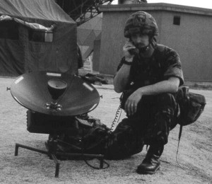 Once the data is presented in an interpretable form to the trained photo interpreter, the output of intelligence can be expected. However there are stages of interpretation each requiring increasing amounts of time dependent upon what and how much information is required from how many photo frames/prints. Specific questions at precise locations would get the fastest response. A request like general surveillance activity over a broad front will take days, often running into double figures. The size of target and deception measures employed will make the task easy or difficult. Increasingly computer software is being used to help the human interpretation, but it is still a formidable task to detect small targets.
Real time intelligence literally means information on an activity as it happens. Near real time is a more realistic possibility. Timely intelligence is the one which permits sufficient reaction time to deal with events as they happen. To elaborate, information about static targets is really not time critical because static targets cannot move after being detected. But information about mobile targets is extremely time critical. In the time taken to react from detection, typically few hours in average conditions, the mobile target can/will move away. Definitely if enemy attack is likely, it could resort to deception measures. It could conceal itself, it could mix amongst the innocents. Even large but mobile targets are tough nut to crack.
The example of Scud TEL (Transporter Erector & Launcher) hunt during Gulf-War-91 is revealing. About 2493 sorties backed by the most elaborate detection infrastructure including satellites in space, AWACS in the area etc produced only 25. kills. If this is the case with a set of vehicles measuring nearly 20 meters along with fiery signature of Scud missile launch, imagine the possibility against few individuals terrorist masquerading as innocent civilians.
The shortest time cycle from detection to useful information for tactical commanders in KOSOVO during the 78 day air campaign in 1999 was about 10 minutes. It involved a U-2 collecting intelligence, sending it back to Beale Air Force Base in California, USA through SATCOM. From USA it was forwarded to Fort Meade, Maryland for analysis and then back to theatre.7a Mark Hewish, an expert estimated this time to be 15 minutes using Predator UAV in conjunction with Global Broadcasting Systems.7b
During the ongoing Afghan war this cycle has been reduced to few minutes employing conventional model.
There was another interesting example of target detection to target destruction during Kosovo Air Campaign. An F-117 pilot on his return from a live mission spotted a MiG-29 ac on one of the airfields. He relayed this information via SATCOM to a ground station in USA, from where the data was passed to Norfolk Virginia to the Tomahawk mission planning facility. From Norfolk Virginia a new mission plan was sent to a ship in Kosovo area for onboard Tomahawk missile. The missile after programming was launched against the detected MiG-29. 101 minutes elapsed between target detection and its destruction.7c
During the ongoing Afghan war this cycle has been reduced to few minutes employing conventional model. However armed Predator UAV can detect and immediately destroy a target if it has been so programmed. So in cleared cases detection to destruction cycle has been shrunk to seconds.
Electronic Intelligence (ELINT)
This refers to Intelligence on adversary electronic systems, mainly the Radars. It could also include other electronic sensors used for detection like the Electo-Optic, Infra-Red, Thermal Imaging, Laser Systems etc. Here again fundamental requirement is to find the exact location of electronic systems. In this there are limitations. The pinpointing error can vary from tens of meters at best to errors in kilometers at worst. It depends upon the means employed, their distance from the target etc. Thus satellites when employed in ELINT role will have largest errors. Also the error will be a function of the orbital height of the satellite, whether low earth orbiting or geostationary at 36090 kms. Further the satellite, larger the error.
…for intelligence inside buildings, underground structures, forested areas etc HUMINT will continue to be the main source for years to come.
ELINT equipment mounted on aircraft and UAVs will provide better accuracy. No doubt the PGMs accuracy in 2-3 meters is good for assured target destruction, in reality the accuracy will get degraded to that provided in locating the electronic emitter.
Apart from physically destroying radars i.e. hard kill, there are means of soft kill. That is to insert malicious software in enemy radar to corrupt its information. Electronic Counter Measure (ECM) systems are meant to do precisely this. This, to be successful, requires a lot of technical information on electronic parameters of the concerned system—sometimes, as many as ten parameters, like frequency, pulse width, PRI, power output and so on. As the knowledge on parameters reduces, so does the ability to fool that system.
This is not all. As a part of Electronic Counter-Counter measures (ECCM) the manufacturers now build in many variable frequencies in Electronic Systems. The moment the system senses ECM it switches on its ECCM. Thus again diluting efforts towards soft kill.
Finally one is never too sure about the amount of success that occurs in soft kill. Even in case of hard kill, it is difficult to guess the time required to repair and reuse the system.
Signal Intelligence (SIGINT)
This refers to eavesdropping on signal communication using electronic medium. During 1905 Russo-Japanese naval war, Japanese used signal intelligence to great advantage in defeating the Russian Navy.
Having seen limitations of the various means of intelligence gathering, it becomes clear that the multiple inputs must be co-related to derive as complete a picture or mosaic as possible
During World War II the Allies broke the German communication encryption code called “Enigma” as well as the Japanese communication code. The Allies then used the Intelligence gained to their great advantage. For more than three decades under the unacknowledged “ECHELON” sigint system, the USA along with UK has monitored telephonic conversations on a world wide scale. But there are limitations in the system which one can exploit to his advantage.
The obvious ploy is to deliberately feed wrong information. However this will need corroboration with other sources of intelligence. Second is the use of local multiple dialects, which the enemy may not be familiar with. 200 plus Indian dialects will enable this possibility easily. During 1971 Indo-Pak war this tactic was made use of.
Intelligence on Sub-Surface Locations
This heading might seem odd. The fact is that so far almost all the sensors as described for Intelligence collection gather information on subjects located on and/or above the land/water surface. Intelligence collection sensors have tremendous limitations in discerning objects underground.
Even inside buildings, the layout is difficult to discern unless HUMINT or buildings blueprints are available. Militaries, the world over, locate many of their centers underground.
The conventional sensors can not penetrate earth surface to see underground. Thus, Intelligence on anything which is located beneath earth’s surface is rather difficult to come by.
Even inside buildings, the layout is difficult to discern unless HUMINT or buildings blueprints are available. Militaries, the world over, locate many of their centers underground. This gives them high degree of protection against prying eyes of the Intelligence sensors, unless poor camouflage of the sight gives away its location.
Experiments are on to develop Radar which could penetrate earth’s surface to a reasonable depth. However the progress on penetrating bombs and specialist fuses which can count the number of floors and then allow detonation at a predetermined depth is more noteworthy. Micro UAVs promise to enable recce inside buildings. Limited capability exists against underwater objects. Therefore, for intelligence inside buildings, underground structures, forested areas etc HUMINT will continue to be the main source for years to come.
Future Possibilities
Having seen limitations of the various means of intelligence gathering, it becomes clear that the multiple inputs must be co-related to derive as complete a picture or mosaic as possible. Good and accurate HUMINT will continue to play a major part as far in counter insurgency. Nevertheless we must also look at future possibilities and examine their integration.
 Some of the ideas suggested below possibly are already in use at some places. They are mentioned to underscore the need for their greater usage in counter insurgency. Digital cameras and Handy Cams Video camera operated by one of the crew in a light two seater aircraft earmarked for surveillance may enable capture of relevant data. Greater amount of surveillance by light aircraft must be planned. Micro-lights which are much cheaper and easy to operate must be re-examined for inclusion in surveillance duties. In many areas excellent mobile telephony connectivity exists.
Here the use of telephony or SMS must be incorporated. The emerging smart phones have good capability to photograph and SMS the data in real time. Real time intelligence often does not need encryption, so commercial capability can be used.
To conclude, all of us tend to be over optimistic about the information possible from — various technical sensors used for Intelligence collection. The out of context description of sensors by manufacturers highlighting only the best capability in ideal conditions is partly responsible for the illusion. Actual Intelligence gathering and its analysis is a painstaking, time consuming activity. Its result requires continuity for accurate results. As newer sensors are developed, so are the counters. Intelligence can seldom be 100 percent correct. A good planner caters for this shortfall and contingencies in his plans. Only when we understand the limitations, we can devise a sound plan.
Notes
- Micheal O’Hanlon, “Technological change and the Future of Warfare,” Brookings Institution Press, Washington, D>C> 2000, p 127.
- Ibid, p 121.
- James G, Lec, Major, USAF, “Counter Space Operations for Information Dominance, “Air University Press, Maxwell Air Force Base, Alabama Oct 1994, p 10.
- Ibid, p 34.
- Ibid, p 141.
- William E. Buirows, “Deep Black – The Secrets of Space Espionage” Banton Press, New York, 1988, p 312.
- Revisit lime for USA’s LANDSAT satellite is 17 days. Jane’s Defence Weekly 26 Aug 98; to reduce this time drastically, USA’s DARPA has proposed DISCOVERER-2 system. It has a plan for 24 satellites simultaneously in orbit so that no place on globe was out of sight for more than 15 minutes. TDW 26 Aug 98.
- To be able to use satellite imagery for accurate missile guidance, aircraft navigation etc stereoscopic data is required for digital terrain model. Few satellites enable proper stereoscopic imagery. Defence News 8 Feb 1999, p 8.
- John A. Tirpak, “KOSOVO Retrospective” Air force Magazine, Journal of Air Force Association, USAF, Apr 2000, p 29.
- Mark Hewish, International Defence Review 2/97, p 55.
- Defence News 30 Aug 1999, p 6.




this article is garbage