


The Sino-Indian border conflict is a lesser-known border conflict than the well-known Indo-Pak border conflict, having remained mostly in obscurity ever since the 1962 Sino-Indian war, with public and political attention more focused towards Pakistan. However, the recent Skirmishes (2020) on the border have generated a new-found interest regarding policy to be followed vis-à-vis China. In order to be effectively able to design such policies, it is imperative to understand what precipitated this conflict and what demands both sides have. This paper aims to lay down the entire historical and political background of this conflict and explain the factors that influenced the Indian Government’s stand on the borders of Ladakh and the Aksai Chin region.
Why Aksai Chin?
The relatively flat desert region enclosed by the Karokoram ranges in the south, and the Kuen Lun range in the north, is referred to as Aksai Chin, meaning ‘White stone desert’. Historically, this region has been more or less uninhabited, mainly serving as a trade route. However, this region has been the gateway to Tibet for Central Asian invaders. The Russian conquest of Central Asia during the Great Game, and the perceived threat to British India and Tibet, led to British attempts to explore and demarcate the area, in order to be able to form defensive positions against Russia, an exercise in which it enlisted the Help of Qing China, which was (intermittently) the suzerain of Tibet, and was viewed as a valuable ally by the British. With the end of the Great Game, the need for defence against Russia wasn’t necessary, and so the region fell into strategic insignificance. However, the region does have strategic importance for China, as it connects the Chinese provinces of Xinjiang and Tibet (See Map 1).
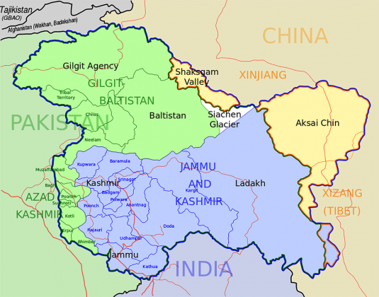
MAP 1: A MAP OF THE KASHMIR REGION, SHOWING AKSAI CHIN, WITH XINJIANG TO THE NORTH AND TIBET TO THE SOUTH
Origins
The origins of this conflict date back to the 18th century rivalry between the Russian Empire and the British Raj over control of Central Asia, which was dubbed “The Great Game” by the British, as well as the Russians who called it the “Большая Игра (Bolshaya Igra)”. The Russians aimed to colonize what they viewed as the savage and uncivilized Asians, in an effort to try and conquer British India. Multiple theories have put forward to try and explain the reasons behind the same. Hopkirk attributes it to two reasons: One, the desperate Russian need of a warm water port, and Second, the psychological reason. It had been from the East that Mongol Hordes had come, the same hordes who ransacked the Duchy of Muscovy[i]
A third explanation suggests that Russia did not have the power to compete with European powers, and thus turned East in the hope of easier conquests and gaining more resources. Starting out more than 2,000 miles away from the Borders of India, The Russians would ultimately end up placing their furthest outposts barely 20 miles from the Indian border. The events of this period would go on to have far reaching consequences of Geo-politics in Central Asia, the repercussions of which are still felt to this day.
The French Connection
Napoleon’s advance up to Egypt, which he viewed as a staging point for the invasion of the Invasion of British India, started a panic amongst the officials of the English East India Company, who scrambled to consolidate its hold on India and defend India against the threat of French Invasion. To do so, they sent out a Naval task force under Admiral Horatio Nelson, which beat the French Navy at the Nile, attacked and defeated Tipu Sultan, a long time Ally of the French. Now Napoleon hatched another plan to try and conquer India, this time in coordination with Russia. The plan called for 35,000 French Soldiers to rendezvous with 35,000 Russian troops in Russian territory, and then march down South through the Central Asian Khanates and cross the Indus. The French were to take control of the Southern Peninsula, and the Russians would control the North[i]. However, Napoleon was bogged down in European Conflicts and could not spare forces for this expedition.
A Mad Endeavour?
Paul I, the Tsar of Russia had become impatient and refused to keep waiting for Napoleon, and decided to launch the invasion on his own, hoping that it would galvanize the French into sending their men. A secret invasion force was hastily put together, consisting of 22,000 troops, with the aim to ‘free the Indian princes and rajahs from their English bondage and to make India a dependency of Russia just as she has been of the English’. The Secondary aims of this force were to capture Khiva on the way to India, to free the massive number of Russians who had been forced into slavery, and then proceed to capture Bukhara to keep it out of Chinese hands[ii]. This force was also supposed to map the area, as maps of the region were not available, and try and make contact with the natives to turn them against the British. Simply put, the force was being sent in blind, with no knowledge whatsoever about the terrain they were to traverse, lack of information regarding British possessions and no clue whatsoever about the locals and their allegiances. This combined with the force being struck by a blizzard further deteriorated the situation. However, by this time the imperial court had had enough of Paul’s grandiose dreams, with speculations over his mental health, and he was soon assassinated in a Palace Coup by his son, who immediately issued orders to recall the troops.
The Long Run
By now, the Russians had figured out their weaknesses, and realized that any drives southward wouldn’t be that of lightning campaigns but instead would be a long-drawn-out process. The British, realized that it would have to defend itself from potential Russian invasion. The first step in this process was to consolidate their earlier existing holdings. The Russians focused their efforts on subduing the frontier tribes, and to build up a strong base from where to launch their expeditions into Central Asia.
Meanwhile General Zorawar Singh Kahluria, of the as yet Independent Sikh Army, who was also nicknamed the “Napoleon of India” for his military prowess, and was responsible for conquering Baltistan and Ladakh, launched an invasion of Tibet in 1841. However, Chinese forces came to the aid of the besieged Tibetans, and defeated the Sikh Expeditionary Force, killing General Zorawar Singh in Battle. The combined Sino-Tibetan force then proceeded to besiege Leh, where they in turn were beaten back by Sikh reinforcements[iii]. The Sikhs pursued the Sino-Tibetan force, annihilating them at the Battle of Chushul. This led to the treaty of Chushul, where “The Maharajah Sahib, with God (Kunchok) as his witness, promised to recognize ancient boundaries, which should be looked after by each side without resorting to warfare.”[iv] Simply put, both sides did not have any talks about the frontier, but just agreed to honour ancient frontiers, which were demarcated by natural obstacles.
Mapping the Frontiers
Tensions between the Sikhs and the British saw the British taking control of the Sikh empire, including Ladakh. With their new conquests, and further Russian expansion into Central Asia left 3 buffer zones between Imperial Russia and British India; Persia, Afghanistan and Tibet. This paper focuses more on Tibet. Both sides now turned to address the lack of knowledge about the frontier regions, commissioning research projects and mapping projects to gain knowledge about the frontiers. Most notable here is the role of the ‘Pundits’, who were learned men from the Mountain regions of India, who would be sent in disguises out to the frontiers and behind enemy territory, to secretly record cartographic and astronomical data to make maps of the region.
These expeditions soon made a worrying discovery; there were many regions in the frontier that were uninhabited, nor claimed by any country. Both Calcutta and Whitehall worried that these territories could be claimed by the Russians. In order to avoid this, Afghanistan and Tibet (China) were encouraged to claim these areas as part of their territory to prevent Russian expansionism[v]. Tibet and China had been invited twice, in 1846 and 1899, by the British to have a joint committee to resolve the Border, however, both times the Chinese refused to participate.
Now this is where one concept comes into play, the difference between ‘frontier’ and a ‘boundary’. “A frontier is a wide tract of border land which by virtue of its ruggedness or other difficulty, served as a buffer between two states. A boundary is a clearly defined line expressed either as verbal description (delimited), or as a series of physical marks on the ground.”[vi] Here it must be noted that for isolated areas such as Tibet, the western concept of absolute boundaries did not make sense, as frontiers served the purpose perfectly well. However, with the advent of European colonists and countries being forced to accept the European concept of having absolute boundaries, countries had to send cartographic expeditions to map their domains, which, due to factors such as terrain and technology, left many blank spaces on maps, which were simply marked as ‘undemarcated’.
These undemarcated frontiers were thus open for interpretation by cartographers, and many different boundaries were suggested by different British cartographers to be the boundaries of the domains of the Empire. These are as follows:
Johnson Line: Presented by William H Johnson of the Survey of India, he made a map of Kashmir, showing the entirety of Aksai Chin in the Domains of the Maharaja of Kashmir. Some have attributed Johnson’s map to be made for his personal gains, he was a disgraced officer, who aimed to regain his status[vii]. This new map of his (see map 2 on page 4) incorporated 18,000 square kilometers into the Domains of the Maharaja of Kashmir, who immediately took control of these areas and even built a fort at Shahidulla (Xaidulla), north of the Johnson Line. Johnson in turn, was rewarded by the Maharaja and made Governor of Ladakh. The Johnson Line was later acknowledged by the Qing Government, who in 1893 presented the British with their own map of the border, which matched the Johnson Line (See Map 3 on page 5). However, this line was considered to be ‘Militarily unsound’[viii].
Macartney-MacDonald Line: In the 1870s, British officials toyed with the Idea of handing over the Aksai Chin region to China. They felt that it would be easier for the British to guard a frontier up to the Karokoram range, instead of one at the Kuen Lun range. They also felt that a strong Chinese presence in the region would deter Russian efforts to take control of the region, as the region although claimed by British India, was in reality no man’s land. The Chinese were requested to take control of the region, but no reply was received from the Chinese. The British decided to treat the request as accepted[ix].
However, the end of the First World War destroyed the need for protection against Russian expansionism, and in this context the British Re-adopted the Johnson line. From this period up to Independence, both of the above-mentioned lines were used on British maps. In 1954, Nehru ordered new maps to be printed which would ignore any ‘lines’ and would be a final and firm border not open to discussions with anybody. The Indian government decided to adopt the border on the basis of the Johnson Line. The Chinese however, ignored this claim, and Built a road through Aksai Chin (See map 2 on page 4), and claim a line much more to the south (See map 2 on page 4). It was only later that India found out about the road, and protested. Nehru reiterated in parliament, that India considered the Johnson line as the Boundary. When unofficially offered by Zhou Enlai to drop his claims to Aksai Chin and recognize the McCartney line in return for Chinese recognition of NEFA as Indian Territory, Nehru refused any negotiations until Chinese troops vacated Aksai Chin. The Chinese also believed that India was an imperialist power, and wanted to evict the Chinese from Tibet, and to make Tibet a buffer zone, as was the official British Policy. Thus, China was determined to protect its interests in Tibet and Aksai Chin, and when diplomatic talks broke down, they decided to “Punish and end Indian aggression on Chinese territory along the Border”[x].
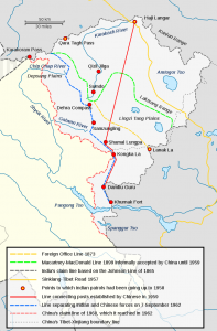
MAP 2: A FULLY COMPREHENSIVE MAP OF AKSAI CHIN
These are the factors that finally led to the 1962 Chinese offensive in Aksai Chin, where Chinese forces advanced all the way up to their Claim line at the Karokoram range, where the ‘Line of Actual Control’. The situation remains explosive, with the world’s two largest armies facing each other, with there even being hand to hand combat on several occasions, threatening to make the situation much worse. Any diplomatic resolution of this issue would require both sides to make concessions, which appears unlikely due to the immense amount of national pride and prestige that has been attached to this conflict.
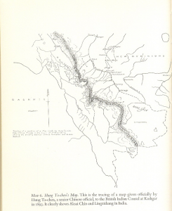
MAP 3: THE CHINESE MAP PRESENTED TO THE BRITISH IN 1893, ACKNOWLEDGING THE JOHSON LINE, SHOWING AKSAI CHIN IN INDIA
Endnotes:
[i] Hopkirk, Peter: The Great Game; On secret Service in High Asia, John Murray, 2006 Reprint
[ii] Bondarevsky, Gregory L: The Great Game; A Russian Perspective, 2002. (https://www.academia.edu/32269288/The_Great_Game_A_Russian_Perspective)
[iii] Bondarevsky 2002, Ibid.
[iv] Huttenback, Robert A.: “Gulab Singh and the Creation of the Dogra State of Jammu, Kashmir, and Ladakh”, 1961.
[v] Shakabpa, W. D: Tibet; A Political History, New Haven, 1967. (Dogra-Tibetan Treaty of 1842)
(https://tibet.net/wp-content/uploads/2014/10/political-treaties-of-tibet…pdf)
[vi] Hopkirk 2006, Ibid.
[vii] Lt Gen Panag, H.S: The Spaces Between Nations-Frontier, Border & Boundary; The Times of India, July 12, 2017. (https://timesofindia.indiatimes.com/blogs/shooting-straight/the-spaces-between-nations-frontier-border-boundary/)
[viii] Guruswamy, Mohan: The Great India-China Game; Rediff, 23 June 2003. (https://www.rediff.com/news/2003/jun/20spec.htm)
[ix] Col Verma, Virendra Sahai: Sino-Indian Border Dispute at Aksai Chin; A Middle Path for Resolution, WordPress, 2010. (https://chinaindiaborderdispute.files.wordpress.com/2010/07/virendravermapaperborderdispute.pdf)
[x] Col Verma 2010, Ibid.
[xi] Garver, John W: China’s Decision for War with India, 2003. (https://indianstrategicknowledgeonline.com/web/china%20decision%20for%201962%20war%202003.pdf)
MAP CREDITS:
Map1:Mapsof.net. (https://www.mapsof.net/kashmir/map_of_Kashmir)
Map 2: Public domain, Wikimedia Commons
Map 3. Government of China, 1893, reproduced by Woodman, Dorothy in Himalayan Frontiers; A political Review of British, Chinese, Indian and Russian Rivalries in the region. Barrie and Jenkins, 1969.
Courtesy: https://www.claws.in/aksai-chin-from-napoleon-to-nehru/
 Please wait...
