


Map not to scale.
China’s role as an interested party and its status as a disputant in the territorial issue of Jammu & Kashmir has been obfuscated because the international narrative has been limited to the bilateral dispute between India and Pakistan. Even in Kashmir, the Chinese subterfuge has largely gone unnoticed, under-reported and under-analysed. This special feature provides a historical account of Chinese perfidy and unscrupulous manoeuvres since the colonial days, aimed at surreptitiously acquiring land that rightfully belonged to the erstwhile princely state of Jammu and Kashmir, and, following its accession in October 1947, is a part of India.
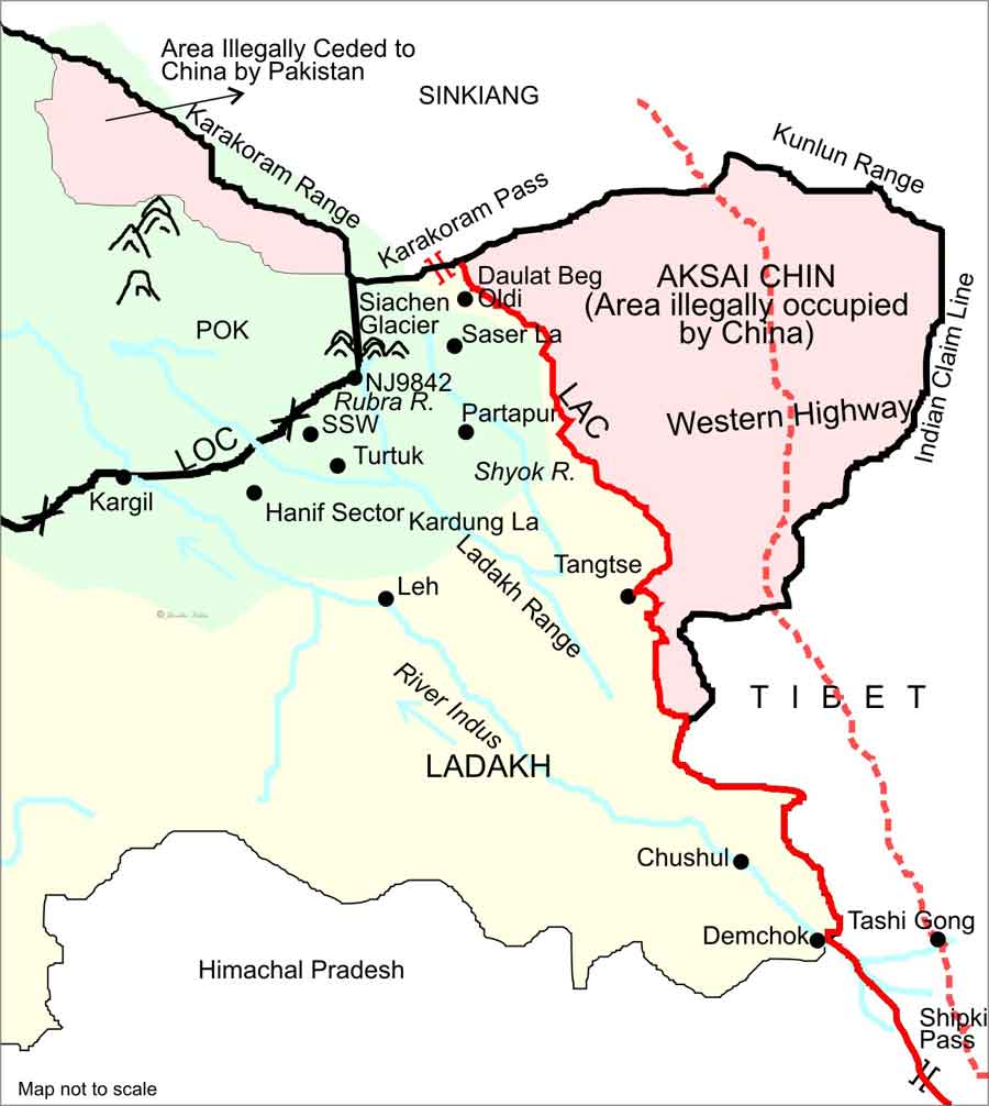
Following the abrogation of Article 370 and reorganisation of the State of Jammu & Kashmir in August 2019, China strongly criticised the Indian Home Minister’s statement in Parliament, in which he had reiterated India’s long-standing position that the state of Jammu & Kashmir includes Pakistan Occupied Kashmir (POK) as well as Aksai Chin.1 The fact of the matter is that the map of India has always included these territories as part of Jammu & Kashmir, along with POK, including the trans-Karakoram tract of Shaksgam which was illegally ceded by Pakistan to China.
China has become increasingly assertive in backing Pakistan’s moves to agitate the issue at the international level. It has tried to trigger discussions in the United Nations Security Council (UNSC) on four occasions since then. Simultaneously, it has continued to designate the issue as a bilateral legacy dispute between India and Pakistan. It has called upon “both India and Pakistan to peacefully resolve the relevant disputes through dialogue and consultation and safeguard peace and stability in the region”.2 Despite being a party to the territorial dispute in Kashmir, China has endeavoured to play down the fact.
China’s role as an interested party and its status as a disputant in the territorial issue of Jammu & Kashmir has been obfuscated because the international narrative has been limited to the bilateral dispute between India and Pakistan. Even in Kashmir, the Chinese subterfuge has largely gone unnoticed, under-reported and under-analysed. Following China’s interference in India’s internal affairs, some Kashmiri leaders have even welcomed China’s growing interest in the Kashmir issue. Former Chief Minister of Jammu & Kashmir Farooq Abdullah has made an outrageous statement that Kashmiris would much rather be under Chinese rule!
In order to understand the Chinese game-plan and its opportunistic involvement in the Kashmir issue, one must revisit history to assess the full extent of China’s insidious role as an illegal occupier of Kashmir’s territory. There is a need to widely disseminate the facts about Chinese territorial grab in the trans-Karakoram tract in order to raise public awareness of the issue, both in India and at the international level. Above all, Kashmiris, including those in POK, should be made aware of the manner in which China has usurped Kashmir’s territory. This special feature provides a historical account of Chinese perfidy and unscrupulous manoeuvres since the colonial days, aimed at surreptitiously acquiring land that rightfully belonged to the erstwhile princely state of Jammu & Kashmir, and, following its accession on October 26, 1947, is a part of India.
Recent References to Jammu & Kashmir at UN
Pakistan Prime Minister Imran Khan raised the Kashmir issue at the 75th session of the UN General Assembly on September 25, 2020. The Indian delegate, exercising the Right of Reply, rebutted Pakistan’s calumnious charges and rhetorical chicanery and stated inter alia that “The only dispute left in Kashmir relates to that part of Kashmir that is still under the illegal occupation of Pakistan”.3
After the seventh round of talks between India and China at the level of the Corps Commanders on October 12, 2020, Chinese Foreign Ministry spokesperson Zhao Lijian said in a briefing a day later that “China doesn’t recognize the so-called ‘Ladakh Union Territory’ illegally set up by India or the ‘Arunachal Pradesh’”. He further blamed Indian infrastructure-development activity for causing tensions stating that China “opposes infrastructure-building aimed at military contention in disputed border areas.”4
In response, Indian Ministry of External Affairs (MEA) spokesperson said at a media briefing on October 15 that “China has no locus standi to comment on India’s internal matters” and that “The Union Territories of Jammu and Kashmir and Ladakh have been, are, and would remain an integral part of India”.5
It is a historical fact that the dispute in Kashmir goes beyond the territory that is still under the illegal occupation of Pakistan, and includes both the territory measuring 5,180 square kilometres (sq kms) in the Shaksgam Valley in the trans-Karakoram tract ceded by Pakistan to China under their so-called border agreement of March 02, 1963, as well as approximately 38,000 sq kms of the territory of the erstwhile state of Jammu & Kashmir in Aksai Chin illegally occupied by China.
Internationalisation of Jammu & Kashmir Issue
India first brought the issue of Pakistani aggression in Kashmir to the UNSC under Article 35 of the UN Charter, in a letter dated January 01, 1948, addressed to the UNSC President. The agenda item was titled “The Situation in Jammu & Kashmir” until the 230th meeting of the UNSC, held on January 20, 1948. However, after Pakistan addressed a “counter complaint” to the UN Secretary General on January 15, 1948, the item was re-designated as “The India-Pakistan Question” in the 231st meeting of the UNSC held on January 22, 1948, thereby obscuring the original issue of “aggression” by Pakistan that India had referred to the UN. The issue has since persisted as a bilateral one, disregarding subsequent developments on the ground including China’s active role in the territorial dispute.
The legitimate frontiers of the Princely State of Jammu & Kashmir comprised a total area of 2,22,236 sq kms, which rightfully belonged to the Maharaja of Kashmir. Upon the signing of the Instrument of Accession on October 26, 1947, the legality of which is indisputable, the territory belongs to India. Of the total territory, 78,114 sq kms are under the illegal occupation of Pakistan, 37,555 sq kms (official Indian statements refer to 38,000 sq kms) under the illegal occupation of China, and a further 5,180 sq kms in the Shaksgam Valley, illegally ceded by Pakistan to China under their provisional “border agreement” of March 02, 1963, have since also been under China’s occupation.
The fact that China occupies approximately 42,735 sq kms of the territory of Kashmir hardly figures in any reference to the Kashmir issue at the UN. It needs to be highlighted on every occasion, whenever the issue of Kashmir comes up.
Historical Background (Kashmir-Xinjiang Boundary)6
China began to acquire control over parts of Xinjiang (erstwhile Chinese Turkestan, also called Mashriqi Turkestan or Eastern Turkestan) in the 1750s, during the reign of the fourth Qing emperor Chien Lung (Qian Long). China claims that “north and east of Karakoram pass beyond the Kun Lun range as far west as the skirts of Pamirs” were added to the Manchu Empire in 1759.7 Chinese maps of the period like Hsi Yu Tu Chi, only showed the lower course of the Yarkand and Shaksgam rivers and there seemed to be no depiction of the valleys along the upper tributaries of these rivers, i.e., the Raskam and Shaksgam valleys, which are well north of the Karakoram Range. The maps only depicted the Kun Lun Range as the terminal point of Qing territory in the south-west of Xinjiang. There is no historical evidence to show that the Chinese ever exercised their authority in the Shaksgam Valley before 1890.8 Nor is there any evidence that Xinjiang ever extended into Aksai Chin.
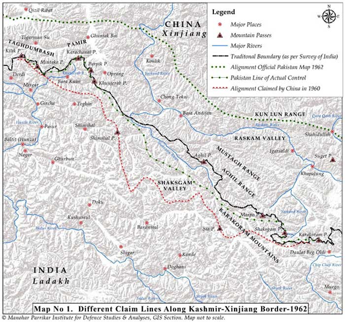
Click to enlarge. Map 1: Different Claim Lines along Kashmir-Xinjiang Border-1962
Raskam lies to the north of the Mustagh Range whereas Shaksgam lies to the south of the Aghil Range. Both these ranges are located between the main Karakoram and Kun Lun ranges. The Karakoram Pass itself is on the Qara Tagh Range, which is a bit to the north of the main Karakoram Range. The Kun Lun Range, further east, had traditionally placed Aksai Chin well beyond the pale of any Chinese control [See Map 1].
Contested Claims of China Over the Terrain
The accounts of William Moorcroft9 and Ney Elias10 during their travels in the region in 1879-80 and Francis E. Younghusband11 in 1889-90 mention that Hunza (also known as Kanjut) was an independent kingdom. The Chinese asserted their authority in some areas traditionally under the control of Mir of Hunza for the first time only in 1890, after they established their hold over Shahidullah, a fort built by the Maharaja of Kashmir around 1865. Shahidullah is south of the Kun Lun mountains and north of the main Karakoram Range. It is located on the Kara Kash River north of the Raskam River. Shahidullah was seasonally inhabited by people of Kyrgyz origin, whereas the seasonal inhabitants in the Raskam Valley south-west of Shahidullah were of Iranian and Turanian origins. The Mir of Hunza had grazing, cultivation and tax-levying authority over both the Raskam and Shaksgam valleys. The inhabitants of these areas recognised the feudatory role of the Mir of Hunza.
The Chinese claim, nonetheless, that Hunza became a tributary of the Chinese empire in the twenty-fifth year of the reign of Qing emperor Qian Long in 1762 A.D. The Hunza version, on the contrary, completely refutes this notion; in reality, Hunza claimed that the Mir of Hunza had defeated the Kyrgyz nomads of Taghdumbash Pamir and extended his control till Dafdar, for which the Chinese, themselves not too happy with these nomadic people, had indirectly encouraged the Mir’s control over the territory and started the practice of exchanging annual gifts with the Mir, who used to send a delegation to Kashgar for such a purpose.
China Leverages British Buffer Politics
From 1890 onwards, the Chinese took full advantage of the British disinclination to establish control over the trans-Mustagh region and gave a distorted twist to Hunza’s gifts to build a case for Hunza’s “tributary” status. This self-serving interpretation was a common Chinese practice regarding states on its periphery with which it exchanged gifts. Except for a short period between 1865 and 1878, when Yakub Beg ruled a part of Turkestan, the Mir of Hunza exercised control over Taghdumbash and Raskam areas. The Chinese official (the Taotai of Kashgar) had to intervene in 1885 when the Sarikolis of Tashkorgan (now a county in Kashgar District, which includes a significant part of the trans-Karakoram tract) declined to pay revenue to the Mir, and from 1896 began to collect the revenue on the Mir’s behalf. During this time, an agreement was also signed with the help of the Chinese Taotai at Kashgar, laying down the northern limits of Hunza that included the Taghdumbash Pamir and the Raskam Valley areas.12
By then, Hunza had actually become a vassal of Kashmir. In 1869, the Mir had recognised the feudatory overlordship of the Maharaja of Kashmir and had started paying tribute to him. In 1891, when the Mir of Hunza revolted, the British assisted the Maharaja in defeating the Mir and re-establishing suzerainty over Hunza. The Mir sought refuge in Yarkand in Xinjiang and quietly submitted himself to the Chinese authority in the hope of getting external patronage.
During this period, the fear of a Russian advance over the Pamirs and into British India had started worrying the British authorities. Their familiar strategy of establishing buffers led them, both directly and indirectly, to invite the Chinese into these areas lying between the Kun Lun and Karakoram mountain ranges. Spotting an opportunity, the Chinese began to step in and the British obliged them by disregarding their gradual physical assertions in the territory along the Taghdumbash Pamirs, which rightfully belonged to the Mir of Hunza, and by consequence of his vassal status, to the Maharaja of Kashmir. Interestingly, the strategic inputs from Elias and Younghusband during the late 1880s and early 1890s also attest to this, though British policy then was to downplay any facts that might antagonise China and push it into the arms of the Russians. For the British, a buffer in the trans-Karakoram region tenanted by China was considered a welcome alternative to the direct presence of Russia on India’s borders.
Based on such inputs from Elias, the then Viceroy, Lord Lansdowne (1888-1893), wrote that “the stronger we can make China at this point and the more we can induce her to hold her own over the whole Kashgar-Yarkand region, the more useful will she be to us as an obstacle to Russian advance along this line”.13 Younghusband was deputed to the region in 1889-90 to both take stock of the ground situation and indicate the British viewpoint to the Chinese. Quite predictably, the Chinese were encouraged by the British position. When the Maharaja of Kashmir’s administration reported in April 1892 that the Chinese had demolished Kashmir’s fort at Shahidulla and erected their own further south in Suget, the British chose to look the other way. In October 1892, the Chinese showed up at the Karakoram Pass to set up a border pillar.
At the instance of the self-exiled Mir, the Chinese were further emboldened to lay fictitious claims to Hunza. Subordinating ‘their claims to their strategy’14 to keep the Russians out of Taghdumbash Pamirs, the British resorted to a policy of drift and let the Chinese claim linger on without significant resistance from their side.
Between 1891 and 1895, the strategic contours of the region changed in such a manner that the Russians too encouraged the Chinese to establish their control over the region and develop it as a buffer. Thus, a memorandum sent by Maharaja of Kashmir with convincing evidence of his claims to Shahidullah on March 16, 1892 was ignored, despite the fact that his administration had erected structures about thirty years earlier in the Shahidullah area, which had passed off as a cantonment. The British Resident at the Kashmir court argued on the contrary that the area was inhabited traditionally by the Kyrgyz who were now paying tribute to the Chinese and it would not be wise for the British to raise this issue.15
Thus, strategic British lapse as well as active Russian encouragement16 emboldened the Chinese to assert their claims in the form of active patrolling by 1895 in the area traditionally claimed by Hunza, and even to the extent of brazenly staking their claims over Hunza itself. The then British Secretary of State proposed to keep Hunza’s claims in ‘theory’ and suggested that the British would not make any claim “except for the purpose of precaution against China ceding it to Russia”.17 Officials like George Macartney (1867-1945)18, the British Consul-General in Kashgar, even went to the extent of stating that the “Government of India should enter into a treaty with China making cession of Taghdumbash conditional on her ability to retain control in the area”.
In the scheme of things that followed, the advice of John Ardagh (1840-1907)19, that the defensible boundary claims of the Maharaja of Kashmir (based on traditional claims of his vassal, Mir of Hunza) be clearly spelt out, was ignored for fear of straining Britain’s relations with China at a difficult moment when it had just forced China to cede territory for the third time (New Territories on the mainland, across Hong Kong) in 1898. The Chinese were thus allowed to assert that the southern limit of the Yarkand territory was the main Karakoram Range and not the Kun Lun as was traditionally the case.20
To make matters worse, the British Government argued, on the contrary, that there was “no strategic advantage in going beyond the mountains (which actually meant the Karakoram and Aghil ranges) over which no hostile advance is ever likely to be attempted…….No invader has approached India from this direction where nature has placed such formidable barriers”. Such self-deceiving arguments led the British finally to propose, through soldier-diplomat Claude Macdonald (1852-1915)21, a line that offered to give away areas lying north of the Mustagh-Karakoram range in return for China relinquishing its shadowy claims over Hunza. Thus, progressively, the genuine historical claims of the Mir of Hunza over the Taghdumbash area were relinquished. It only whetted further the appetite of the Chinese and encouraged them to equate the exchange of gifts with the Mir to a tributary relationship in order to lay claims to the whole of Hunza in subsequent years.
The inputs from informed officials like Adelbert Talbot22, the Resident of Kashmir (1896-1900), and Henry McMahon23, the Political Agent in Gilgit (1897-98), were put aside while the Macartney-Macdonald proposals of 1899 were fashioned out, literally accepting the Chinese forward policy in the region. Interestingly, the 1899 line was not formally accepted by China. The offer was therefore null and void, but the fact that it was made encouraged China to consolidate its control over the Raskam area which had been conceded in the proposal.
By 1911, McMahon had become the Foreign Secretary of the British Indian Government and in line with his earlier thinking, he was ready to uphold the claims of the Mir. However, the strategic priorities of the British changed subsequently through the years of the First World War (1914-1918) and the Russian Revolution (1917), again prompting a policy lassitude in their approach towards the Kashmir-Xinjiang border. In the entire process, Hunza’s attempts to reassert its claims over Raskam went unheeded and unsupported by the British.
Click to enlarge. Map 1: Different Claim Lines along Kashmir-Xinjiang Border-1962
By the end of the First World War, the British, in a departure from the Ardagh Line, advanced the Mustagh-Aghil-Qara Tagh-Kun Lun Line, practically conceding the Raskam Valley to the Chinese by 1927. Following an examination on the ground by officials of the Government of India, the Mir of Hunza was asked by the British in 1936 to abandon his grazing rights in the Taghdumbash Pamirs, which included the Raskam Valley north of the Mustagh Range, and to cease the exchange of gifts with the Chinese. The British view was that rather than risk China twisting the matter of gift exchange to claim suzerainty over Hunza, it was better for Hunza to relinquish traditional rights in Raskam and sever all links with the Chinese.24 The rectification of the alignment was duly carried out in all maps published by the Government of India after 1947, leaving the Shaksgam Valley, to the south of the Aghil Range, within India. This was regarded as the traditional frontier of British India, and later, as the frontier of India after 1947 [See Map 1].
 Please wait...

Interesting, informative detailed article on this critical issue of Chinese lust for the expansionism since ages. Lackluster approach by British on the issue, then ruling over India is now costing us dear. China has to be boldly confronted militarily at every possible conflict scenario and diplomacy needs to raise the ante and make China see reality on ground.
“.. Lackluster approach by British…” –
Lackluster??? – At least the British in spite of all other bad things did in British-India, demarcated the boundary with the then northern neighbour Tibet which was the historic McMahon line. China was not in the picture in that historic past and could not be
. And that McMahon line was drawn with whatever technology was available in that era – remember there was no GPS! As the successor to British-India Delhi inherited a treaty with Lhasa for security and protection, and when China invaded Tibet 1947-49, Tibetan authorities pleaded with Delhi for military help which Nehru reneged on.
Note that all the sovereign territory loss has happened since 1947 and is happening presently is due to spineless India’s political masters to date (excepting Indira Gandhi). China has settled border with Myanmar (Burma) on the basis of the same Mcmahon line. So is the case with Shaksgam Valley – China did recognize the McMahon line with POK there, otherwise there was no necessity of Pakistan signing off that part of Kashmir territory to China.
The British did a few great things for India. The Andaman Islands would be today with Indonesia, had the British not secured that territory. International boundaries between nation-states are decided by fighting wars and India must fight her wars for sovereignty. China has been waging war by “stealth” ever since the 1950s and naively India is succumbing to that. It seems the Indian Army is willing to fight war only with Pakistan and not with China. I am really at a loss at the Indian mindset blaming always others for their own failures as in here “British … ruling over India is now costing us dear…”.
Something that almost many Indians has forgotten. The land that we don’t even show in map. Only way India can get this land is to first become a developed country and develop its military capability far beyond what Chinese have now. Once india will prosper all our lands will come back.