Pakistanis have always been bad losers. Three successive defeats at the hands of the Indian armed forces in as many decades of their country’s existence did little to alter their ego to try one-upmanship with India; and in 1984, less than a decade and a half after its historic humiliation in the paddy fields of Bengal, the Pakistani military was up to its tricks again, this time around in the uninhabitable heights of the Siachen Glacier.
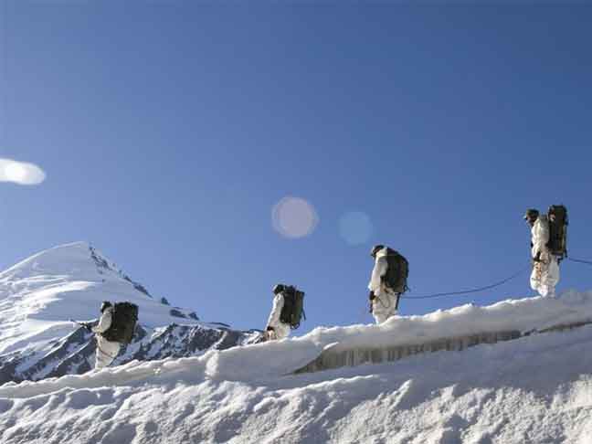
75 kilometres long and varying in width from 2 to 8 kilometres, the Siachen Glacier lies lapped in the world’s most forbidding mountainous region that make up the northwestern extremity of India. Forming part of the Karakoram Range beyond Ladakh in the Jammu and Kashmir State, it occupies some 10,000 square kilometres, at heights rising from 12,000 to 23,000 feet above sea level. After the first Indo-Pak War of 1947-48 the old kingdom of Jammu and Kashmir was divided into two along the ceasefire line, which left India in possession of the current J&K State comprising the southern Jammu, the central Kashmir, and the northern Ladakh regions.
After the Sino-Indian War of 1962, the Chinese returned all territories they had occupied in the Northeast (practically the whole of what is Arunachal Pradesh today), but had held on to their gains in the Ladakh Sector…
The ceasefire line survived the 1965 War, since both sides returned the captured territories as per the Tashkent Accord. But it got altered to the current Line of Control (LoC) after the 1971 War since India had unilaterally declared the ceasefire, rendering neither party obliged to return the seized territory. However the starting and terminating points of the LoC remained unchanged. It terminates to the north at a point in the Karakoram Range, identified by the map reference NJ 980420, popularly referred as NJ 9842, the area beyond having been considered worthless militarily, being void of human habitation. The LoC from NJ 9842 was vaguely defined by the agreement to extend ‘thence north to the glaciers’ right up to China’s southern boundary. The genesis of the Siachen conflict lay in the interpretation of that definition by India and Pakistan.
After the Sino-Indian War of 1962, the Chinese returned all territories they had occupied in the Northeast (practically the whole of what is Arunachal Pradesh today), but had held on to their gains in the Ladakh Sector, apparently for their need to secure the Aksai Chin Highway between Leh and the province of Zinjiang in Southern China. A year later they also managed a boundary settlement on the Karakoram with Pakistan, wherein the latter ‘yielded’ the Shaksgam Valley, an area of 4853 square kilometers, out of what was rightfully Indian Territory. The southern boundary of China was thus pushed closer to J&K. In less than two years work started on the Karakoram Highway between Pakistan and China, which was completed in 1978. Now there were two highways, one from Tibet to Zinjiang in China and the other from Northern Pakistan to Zinjiang, aligned close to the region, raising serious security concerns for India.
Pakistan began the mischief with a cartographic misrepresentation early in 1980s, displaying the LoC on its maps as a straight line proceeding northeastward from NJ 9842 to the Karakoram Pass. Surprisingly, in the 1970s itself, inadvertently or otherwise, some international publications of repute too have been showing the LoC wrongly aligned on their maps. Alongside, Pakistan had also been actively encouraging international mountaineering expeditions into the Karakoram from its territory. By 1978, alerted by the faulty international maps, and indications of Pakistan staking claims to the area by projecting the expeditions launched from its territory as proof, India too began to undertake mountaineering expeditions. It was the beginning of a mountaineering contest between the two militaries. Exchange of protest notes followed, each party complaining of the other intruding into its territory. Finally in August 1983, through one of the notes, Pakistan made its intention clear by asserting its own interpretation of the LoC, to be leading straight northeastward to the Karakoram Pass from NJ 9842.
The first Indian expedition led by the renowned army mountaineer, Colonel N ‘Bull’ Kumar1, to Teram Kangri, brought indisputable evidence of the foreign expeditions entering the glacier from the Pakistan side. The army had also had evidence of an abortive attempt Pakistan made in September-October 1983 to occupy passes west of the glacier. Intelligence received in January 1984, of Pakistan’s large-scale purchases of high altitude equipment, removed whatever doubt there might have been of its intentions. The Indian Army, obtaining the government’s approval, occupied the Saltoro Range west of the glacier. This was essentially in keeping with the definition of the LoC extending ‘thence north to the glaciers’ from NJ 9842, since ‘north’ by the conventional logic of delineating a geographical boundary, meant northward along the nearest watershed2, which in this case happened to be Saltoro.
The main pass in the Saltoro Range is Bilafond La, which Pakistan has been using to cross over. There was yet another negotiable pass, the Sia La. It was decided to deny these passes to the enemy as a precautionary measure. A small military presence of the kind, which was a cost-effective option, was considered sufficient to contain the Pak adventurism. The word ‘Siachen’ means mountain rose, which grew in abundance near the snout of the glacier. ‘Pakistan has been getting into our rose garden by the gate of Bilafond La’, said a simile among the army planners. ‘Let us close the gate permanently’. And so it was closed.
The transport helicopters India had at the time just couldn’t reach such heights.
Bilafond La was at an altitude of 18,000 feet, and Sia La another 2000 feet higher. The induction and sustenance of troops at such extremes of terrain and weather posed a logistics challenge no army in the world had ever had to face. But the senior commanders involved –Lieutenant General ML Chibber and Major General Shiv Sharma – contended that ‘it would be easier to fight the elements than a determined enemy’. If the Pakistanis occupied the passes first, it would be a military impossibility to dislodge them, given the advantages such heights offered to the defender. It had to be done, and the army geared up to take the bull by the horn.
Troops were to be inducted in April 1984 as soon as the weather permitted, to pip the enemy at the post. A heli-borne operation was the only option, since the enemy air reconnaissance would have picked up any troop movement on foot. The transport helicopters India had at the time just couldn’t reach such heights. The only machine that could do it, the Cheetah – indigenous model of the Alouette – could barely carry two men. Even then there was no infrastructure that would need to conduct an operation of such magnitude. It became a race against time to put in place the aviation fuel, technical support, landing and holding facilities and suchlike. ‘Operation Meghdoot’ was on.
The first troops to land, one officer and two men, jumped down from their hovering copters 3 kilometres short of Bilafond La on 13 April 1984. (To land the copter in soft snow without ascertaining the ground condition would have been suicidal.) Gritty and courageous, the three men, swiftly identified safe spots for copters to land, and reinforced them with some sacks of flour for the skids to touch down. The machines could now land. It took seventeen sorties for a platoon to be ferried across, as the weather held mercifully. A lance naik at the head of a small party soon made it to the pass and raised the Tricolour. Before the day was over the platoon had occupied the Bilafond La Pass. These men were now on their own with no artillery to support them, and except for the fragile radio link, cut off from the rest of the world until the next copter sortie arrived.
The reaction of the Pakistan Army was as fast as any that could be expected of a force under the situation.
Frequently as it occurs at high altitude, the weather suddenly turned foul with a raging blizzard, and the second lift, which was to follow immediately carrying the next platoon to Sia La at a higher altitude, had to be put off. To compound matters, with the drop in temperature the radio contact with the platoon at Bilafond La was lost. It would be three days before the weather cleared and the platoon made contact again. It was safe; and working on the position. The second lift for Sia La was taken up on 17 April.
The Indian Air Force flew 32 sorties to Sia La that day, with hardly any technical support, creating a record in itself. The troops, put down 5 kilometres short, made the gruesome trek over the slopes the same day to occupy the pass. With the weather holding, some supplies could be ferried across to Bilafond La as well. The Pakistanis didn’t take too long to find out what had happened. The same afternoon one of their copters flew over the passes. What they saw below couldn’t have left them with any doubts – they had been thoroughly outsmarted.
The reaction of the Pakistan Army was as fast as any that could be expected of a force under the situation. In a week’s time, the ‘Burzil Force’, a task force they had raised to occupy the passes under an operation codenamed ‘Abadeel’, had been spurred on to faster pace; and barely after a week of the Indian presence being sighted on the passes, forward elements of the force had appeared on the western slopes of the Bilafond La. Tough going as it would have been, the Burzil Force, made up of hardy men from their Special Services Group and the Northern Light Infantry, closed up on the passes and opened fire with small arms and machineguns on 25 April. The war of Siachen – in effect the contest for the domination of the Saltoro Range – to be fought ever since in the world’s highest known battlefield, had just begun.
Taking the passes by assault was of course, a tactical impossibility. The Pakistan Army, stung by the public criticism back home (Benazir Bhutto minced no words while ridiculing Zia-ul-Haq’s military regime for its impotency at Siachen), went into overdrive to salvage its prestige; desperately trying to get a foothold anywhere on the Saltoro Ridge, only to be beaten back in every attempt.
Tactically it was adequate to hold the passes to deny access to the glacier to an intruder. However Pakistan’s repeated efforts to occupy the ridges along the heights, which would have given them no tactical advantage but only scored political points, forced India’s hand to counter the moves by occupying the heights themselves. (An easier option would have been to take the fight to the enemy by attacking him at chosen points; but approval for such a move was not forthcoming from the Government of India.) Soon what was perceived to be a small military presence of a company of infantry or so, turned into a major deployment of troops to the strength of a brigade. And that set in motion a logistics endeavour of unprecedented proportions.
Comparatively Pakistan was better placed to provide logistics support to her troops in the area, with a fairly elaborate network of roads and tracks on that side; whereas India had to support her troops almost exclusively by air. Beyond the Ladakh Range the supplies had to be first ferried over the Khardung La Pass to Shyok Valley along a road at a height of more than 18,000 feet – the highest of the kind in the world – which was open for only part of the year. A bridge where the road passed through a small glacier had to be reconstructed every summer. From the Shyok Valley the stores then had to be ferried across to the glacier, from where the helicopters, both medium and small, lifted the loads to where the troops actually held ground.


Regarding 1989 incident it was decided in a meeting that neither India nor Pak will occupy this post and Pak will be allowed to keep the post it made in 1986 so the claim made in this article that India dislodge Pak from this post in not correct.
A great article indeed Sir. Provides great insight into the genisis of problem and the bravery shown by our troops. Being a Madras Sappers myself, I am proud of role played by Sappers in Siachin.
THE SAGA OF SAICHEN MUST BE INCLUDED IN THE TEXT BOOKS OF INDIA . IT IS HERE WHERE THE POOR SONS , BROTHERS , FATHERS OF FARMER FAMILIES , SHOPKEEPERS , TRADERS , DRIVERS , GOVT BABUS , TEACHERS , POORLY PAID , PENSIONED AND FED FIGHT AND WIN IN INHUMAN CONDITIONS . MY HEART SWELLS WITH PRIDE AS A RETD SAILOR WHEN I KNOW THIS IS WHERE MY COURSEMATES SENIORS AND JUNIORS FROM NDA LAID THEIR LIVES TO BEAT THE PAKIS . THIS IS WHERE MY NCOS , SOLDERS AND JCOS WHOM I NOW SEE LIVING IN PENURY AFTER RETIREMENT GAVE THEIR BEST PART OF THEIR LIVES WHILST THEIR OLD PARENTS , WIVES AND CHILDREN SURVIVED ON MEAGRE SALARIES WHILST THE NETA , BABU CONTRACTER COMBINE OF MOD AND DELHI FILLED THEIR COFFERS . THIS IS WHERE SINCE 1984 TO2014 HUNDREDS OF BATTALLIONS HAVE PROVED THEIR METTLE AND BRIGADES AND DIVISIONS
BECOME INVINCIBLE . THE INDIAN ARMYS MOUNTIAN DIVISIONS HAVE THE ULTIMATE TRAINING AND BATTLE INNOCULATION ON THE ICY HEIGHTS OF SAICHEN . THIS IS WHERE THE BOYS ARE SEPERATED AND BATTLE HARDENED MEN MADE . THIS IS WHERE INDIAS BATTALLION CDRS , BRIGADE CDRS , DIV CDRS AND CORP CDRS ARE SEGRGATED FROM THE WEAK , TIMID AND UNFIT LEADERS. THE SONIA MANMOHAN COMBINE , TOGETHER WITH DISGRACED AIRCHIEF CAUGHT IN AGUSTA BRIBES WANTED THE INDIAN ARMY TO VACATE THE GLACIAR WITHOUT THE CHEATER PAKISTANIS AUTHENTICATING THE POSITIONS AND POSTS HELD BY TWO ARMIES . THIS IS WHERE THE MODERN INDIAN BRAHMIN , BANIA AND THEIR SONS DO NOT SHED BLOOD . THIS IS WHERE THE NETA BABUS OF MOD WHERE THEY DO NOT EVEN STEPOR THEIR SONS GET KILLED OR FROZEN TO DEATH . BEWARE LIKE THE FRENCH FORCES UPRISING IN ALGiERS WHEN FRANCE WANTED TO GIVE INDEPENDANCE TO THE ALGERIANS . THE SERVING AND RETD WILL STRIKE IN UNISON IF EVER THE GLACIAR IS VACATED . THIS IS INDIAN TERRITORY AND NO BASTARD HAS THE RIGHT TO NEGOTIATE OR VACATE FROM THE HEIGHTS . IT IS ONLY THE SOVEREIGN RIGHT IF EVER THE INDIAN ARMY DECIDES TO VACATE THE HEIGHTS . THE ARMY CHIEF HIS FIELD CDRS MUST AGREE IN UNISON . FOR THAT TO HAPPE