Territorial disputes in the South China Sea continue to be a source of tension and potential conflict between China and other countries in the region. Beijing’s intention to exert greater control over the South China Sea appears undiminished.
Once sufficient capabilities are in place for round-the-clock maritime and air presence over the South China Sea, Beijing is likely to declare an air defense identification zone (ADIZ), similar to the ADIZ it declared over the East China Sea in November 2013.
In 2012, China forcibly seized control of the previously unoccupied Scarborough Reef during a standoff with Philippine maritime vessels, despite agreeing to a mutual withdrawal brokered by the United States.
China has seemingly been emboldened by this easy, cost-free conquest: it has since begun construction of artificial islands in the Spratly archipelago that will enable it to extend the range of the Chinese navy, air force, coast guard, and fishing fleets in just a few years.
Once sufficient capabilities are in place for round-the-clock maritime and air presence over the South China Sea, Beijing is likely to declare an air defense identification zone (ADIZ), similar to the ADIZ it declared over the East China Sea in November 2013.
The scale and pace of Chinas dredging activity has alarmed rival claimants Vietnam, the Philippines, Malaysia, Brunei, and Taiwan/ Republic of China (ROC). These countries also claim all or part of the South China Sea.
China and Vietnam have been particularly aggressive in fortifying the approximately 500 islets in the 3.5-million-square-kilometer sea. China angered other nations year by land-filling its claims to expand its influence.
While Beijing tends to characterise most of these features as islands, which can generate their own 200 nautical mile EEZs and continental shelves, Manila instead claims that at most they are only rocks or reefs unfit for human habitation and which can generate a maximum of 12 nautical mile territorial areas.
ROCs role as a peacemaker
Amid rising tensions in the South China Sea, the government of the Republic of China reiterates that, whether from the perspective of history, geography, or international law, the South China Sea Islands, as well as their surrounding waters, are an inherent part of ROC territory and waters.
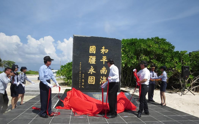
On this position the government has never wavered. Following victory in the War of Resistance against Japanese Aggression, the Navy was dispatched in November 1946 to recover the ROC territory of the South China Sea Islands, and on December 12 of the same year the ROC Taiping reclaimed Taiping Island, bestowing its present name and erecting a stele.
These actions had binding force under international law, and at the time, there were no objections in the international community.
In their arguments in the second hearing for the South China Sea arbitration from Nov. 24 to Nov. 30, lawyers for the Philippines attempted to use discussion of historic maritime rights in the South China Sea to raise issues of maritime delimitation, which were not within the tribunals jurisdiction. Such arguments were purely sophistical.
In his remarks on September 1 last year at the opening of the Exhibition of Historical Archives on the Southern Territories of the Republic of China, ROC President Ma Ying-jeou did not say that ROC maritime claims in the South China Sea were limited to three nautical miles around the islands.
The Chinese people have been operating in the South China Sea for over a thousand years, so the principle of intertemporal law should apply to the resolution of conflicting territorial claims in the region. Moreover, when the ROC government published the Location Map of the South China Sea Islands on December 1, 1947, the UN Convention on the Law of the Sea (UNCLOS) did not yet exist.
From the perspectives of law, economy and geography, Taiping meets the definition of an island under the United Nations Convention on the Law of the Sea, and is sufficient for maintaining human life.
In addition, President Ma pointed out in his preface to the Compilation of Historical Archives on the Southern Territories of the Republic of China that when the government issued a map of the islands in 1935, it was the first time they were divided into four named groups.
This does not mean that the ROC had not claimed sovereignty over the islands before that time. In sum, ROCs sovereignty over the South China Sea Islands remains unaffected by the Philippines willful misinterpretations.
President Ma Ying-jeou has dismissed allegations that Taiping Island—the largest of the disputed Spratly Islands in the South China Sea and controlled by Taiwan—is not an island, but a reef.
The President said that Taiping has no fresh water, no arable land, and is not a natural island, are false. In order to prove his claims, he displayed the dishes he had for lunch on his Facebook page, which showed fried okra, bitter gourd and loofah, all produced on Taiping Island, which lies 1,600 km south of Taiwan.
The Presidents remarks came against the backdrop of a case filed against China by the Philippines at an international arbitration panel to clarify the nature of disputed features in the South China Sea.
While Beijing tends to characterise most of these features as islands, which can generate their own 200 nautical mile Exclusive Economic Zones (EEZs) and continental shelves, Manila instead claims that at most they are only rocks or reefs unfit for human habitation and which can generate a maximum of 12 nautical mile territorial areas.
Ma noted that Taiping is the largest island in the Spratlys and a natural island with its own source of fresh water. Presently, the four wells on the island can produce 65 tons of good quality water per day.
The government is closely monitoring developments in the Philippines South China Sea arbitration, remaining ever vigilant, and working to show the international community the ROCs role as a peacemaker in the South China Sea.
The island is also covered with indigenous plants. It has 147 trees that are more than 10 meters high, he went on, noting that one of the largest, a lantern tree, is about 907 cm wide and is estimated to be 363 years old. The island also produces coconuts, pineapple and bananas.
The President said personnel stationed on the island have made good use of the resources on the island to grow bananas and coconuts, as well as keeping chickens and goats to supply their daily needs, and dogs for security. From the perspectives of law, economy and geography, Taiping meets the definition of an island under the United Nations Convention on the Law of the Sea, and is sufficient for maintaining human life.
On December 12 last year, Minister of the Interior Chen Wei-zen and Minister of the Coast Guard Administration Wang Chung-yi presided over a ceremony on Taiping Island marking completion of the renovated wharf and airstrip, together with the new lighthouse.
Their trip demonstrated that Taiping Island has plentiful fresh water, agricultural produce, and other natural resources, and that it can sustain human habitation and economic life of its own. It thus qualifies as an “island” according to the specifications of Article 121 of UNCLOS, and is entitled to claim the maritime rights that come with an exclusive economic zone and continental shelf.
The government is closely monitoring developments in the Philippines South China Sea arbitration, remaining ever vigilant, and working to show the international community the ROCs role as a peacemaker in the South China Sea.


