


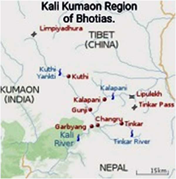
Kali River, name is given to the River that draws its water from various mountainous streams that originate in the neighbourhood of Village Kalapani that is located in NE of State of Uttrakhand. This area is also called the Kali Kumaon Region that has two Valleys namely the Vyas and Dharma Valley, leading to the Watershed of the Greater Himalayas along which runs the well-defined undisputed International Border between Tibet and India.
Bhotias are the local inhabitants of this region.During the Mughal period, the areas to the East and West of Kali constituted the Vayas (Byans) Pargana (equivalent of District) and were inhabited by the Byans. The locals engaged in trade with Tibet through the Passes of Lipulekh and Lampiyadhura. Lipulekh led straight to the Tibetan town of Takalkot (Burang) and was more popular for the trade amongst the Byansians.
Nepal is the only proclaimed Hindu Nation in the world. To the North lies Tibet, to the East lies Sikkim and on the West is Uttrakhand and its Southern belly rests on the Indo Gangetic plains. India and Nepalshare common ties of Hinduism and Buddhism, have an open Border, with a large number of migrants seeking economic prospects in India, their citizens enjoy close family ties by way of marriage too.
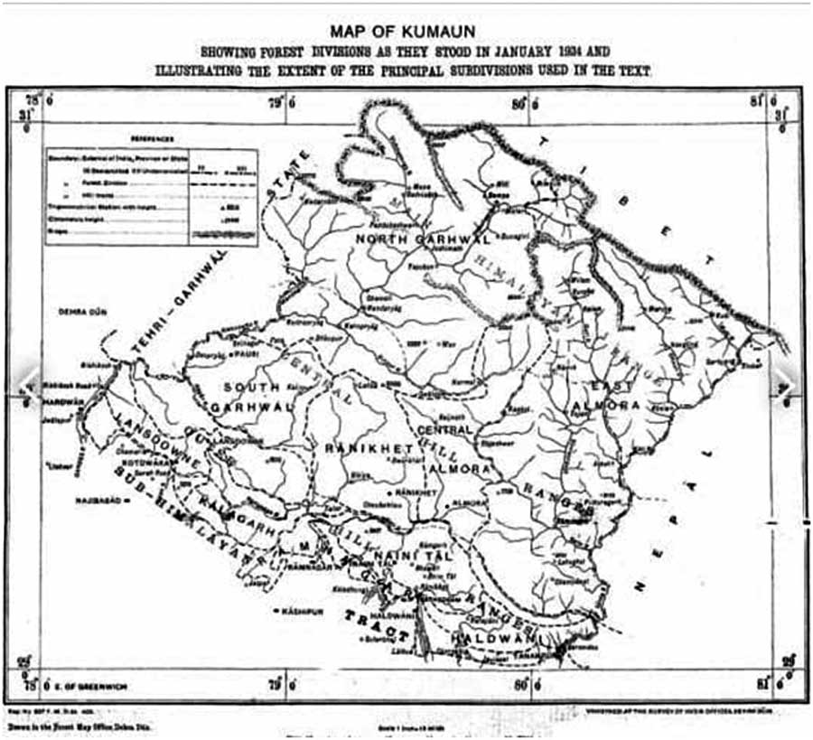
The Geography
The Vyas (KuthiYangti) Valley is located on the SE slopes of the Great Himalayan Watershed that divides Tibet and India. Two main Passes of Valley are Lampiya Dhura (Height 5,530 M) and Mangshya Dhura (5,490 M) .
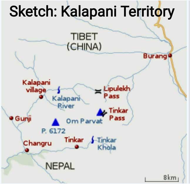
East of Kalapani Village (3,600 M), along the Kali River the Valley leads up to Lipulekh Pass (5,450 /5200M), from Kalapani for about 8 kms the valley gradually climbs up to Nabhidang Camp (4,310M) and thereafter a sleep climb of 2 kms to Lipulekh Pass, across which lies the Tibet Plateau and the garrison of Takalakot (Burang Town).
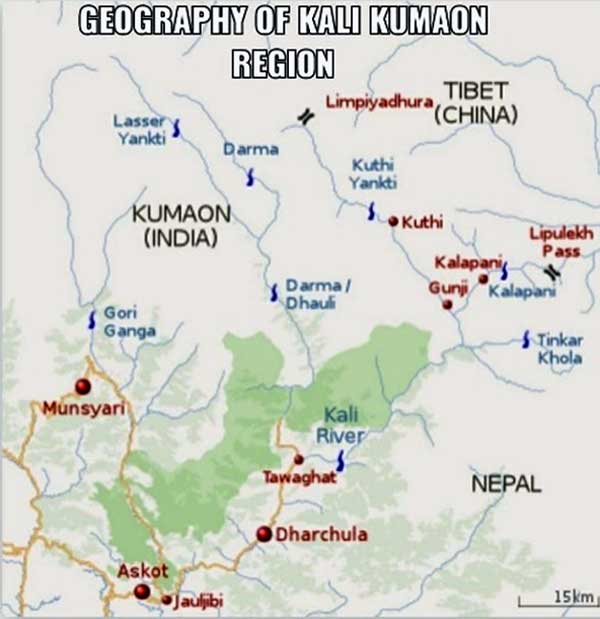
Click to enlarge
In the Vyas Valley, the Villages located here are Gunji, Nabhi, Naplchu, Ronkon, Kuthi, Joling Kong.Further to East in the Lipulekh Valley is the sole village of Kalapani.
KuthiYangti eminates from below Lampiya Dhura, passes through Lake Joling Kong (4,630M) to Kuthi Village, flowing SE it meets Kalapani Riverat Gunji to form the Mahakali River.
In the East of Kalapani Village is Lipu Gad/Kalapani River, at Kalapani Village Tera Gad and Pankha Gad merge with Kalapani River to form Kali River which flows in SW direction to meet KuthiYangti at Gunji Village.
To the SE of Kalapani River is the Tinkar Valley (Nepal) having Villages of Changru and Tinkarconsisting of Byanis. The Tinkar Valley leads up to Tinkar La (Pass)on the Himalayan watershed forming the Tibet-Nepal Border and finally to Taklakot (Burang Town) in Tibet.
Both LampyaDhura and Lipulekh Pass were used for trade with Tibet but Lipulekh Pass leading to Takalakotwas more popular of the two passes amongst the Locals (Byanis). The trek over Tinkar La(from Nepal) was also a shorter and less difficult.
Anglo-Nepalese War 1814-16.
The period of 1791 to 1804, saw the Gurkha Army extending its frontiers, in the West it had occupied the areas Kumaonand Garhwal Regions and in the East Sikkim and to the North parts of Tibet. During the Nepal-Tibet War of 1791 Gurkha Army was evicted out of Tibet with Tibet seeking help of the Qing Emperor. By 1813, Greater Nepal had extended from Sutlej River in the West to the Teesta River in the East.
Click to enlarge
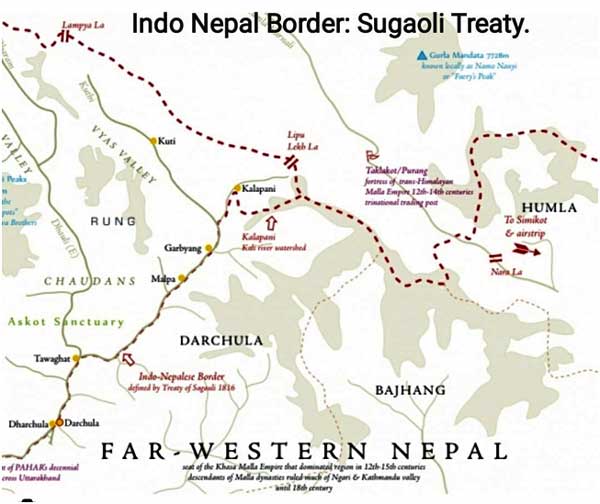
The However, the Anglo-Nepalese War(1814-1816) saw the East India Company defeating and pushing back the Gurkha Army. Following which Sugauli Treaty was signed between East India Company and Gurkha Army.Sugauli Treaty was signed by Rajguru GajrajMisra& Chandra ShekharUpadhaya on behalf of Nepalese King BhimsenThapa and Lt Col Parish Bradshaw of East India Company signed on 02 Dec 1815 and was ratified on 04 Mar 1816.
The Treaty.
The Sugaoli Treaty in its Article 5 states:-
“The King of Nepal renounces for himself, his heirs, and successors, all claims to and in connexion with the Countries lying to the West of River Kali, and engages never to have any concern with those Countries orthe inhabitants thereof.”
(Here lies the current genesis of Indo Nepalese Border Dispute. While River Kali was demarcated as the boundary between Nepal and British India but there was no agreement on the origin of the Kali River, as the Head Waters of Kali River were not included in the Boundary. The British considered the origin of Kali River to be in the East of Kalapani Village i.e. the Lipu Gad coming down from Om Parvat in SE direction flowing down the Valley towards Kalapani Village and called it Kalapani River. In the proximity of Kalapani Village, Tera Gad from Northern Watershed and Pankha Gad from SE slopes flow into Kalapani River and hereafter it takes the name of Kali River. From Kalapani Village Kali River flows in a SW direction for about 8 kms, where another River (KuthiYangti) flowing down the Vyas Valley (Lampiya Dhura) in the West meets it near Village Gunji.)
Even though the Treaty had set River Kali as Boundary of Nepal, the British had the control of areas East of Kali River since the entire Byans Region had been traditionally part of Kumaon. It was only in 1817, the Nepalese made a claim on the Areas East of Kali River stating that it was their territory as per Sugaoli Treaty. The then British Governor General accepted this claim, consequently the Areas East Kali River were transferred to Nepal, there by dividing the Byans Region in two halves separated by River Kali.
Nepal not being satisfied, Nepal then put forward a Claim in 1817 to the Kuthi Valley (Vyas Valley)in the West. Nepal contended that the Kuthi Yangti River which was the western branch at the head waters should considered as main Kali River not the one coming from Kalapani. The British rubbished this claim of Nepalies and they maintained that the stream in the east coming Kalapani
Springs had always been considered as the main Kali River and River got its name from Kalapani. The headwaters of Kali River were not included in Boundary, hence British maintained that Border followed the Watershed. In fact, British in Mar 1817 had maintained that the Zamindars(Land owners) lived west of Kali River in the Kuthi Valley while their Tenants(labours) lived east of Kali River in Nepal. The practice of residents of Nepal coming for work (earning livelihood) in India has continued for centuries and is still in vogue. The British thus kept the control of Kuthi Valley.
Late 19th Century.
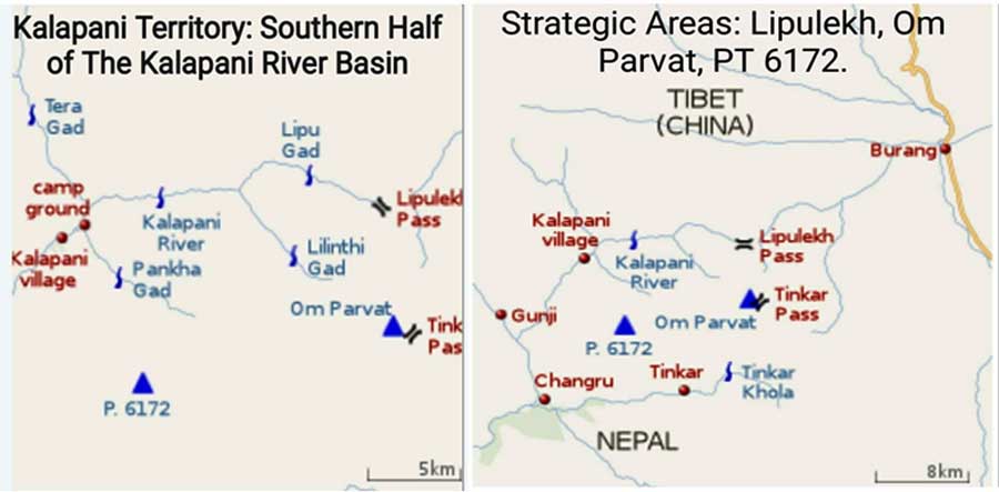
Around 1865, the British shifted the Border from Kalapani Village to the Watershed ie instead of the Kali River to the Lipulekh Pass in the East and heights to the South (calling it the ‘Kalapani Territory’), this was in sync with the British position that the origin of Kali River is at Kalapani Springs.
Click to enlarge
The shifting of the Border entailed strategic reasons as well, since areas included Om Parvat, Mount Api (6,172 M) providing uninterrupted view of the Tibetan Plateau. The British deemed Nepal as British Protected State – calling it as “Independent State with Special Treaty Relations”.
In 1923, the British recognized it as acompletely Independent State and the Treaty of Sugaoli was replaced by “Treaty of Perpetual Peace and Friendship 1923”.
Click to enlarge
In 1950, post India’s independence, India-Nepal signed ”Treaty of Peace and Friendship”, wherein no changes in the Boundary were visualized, the “Kalapani Territory -1865”continued to be shown part of India.
In the year 1951 China occupied Tibet and there was increased Indian activity in this area as
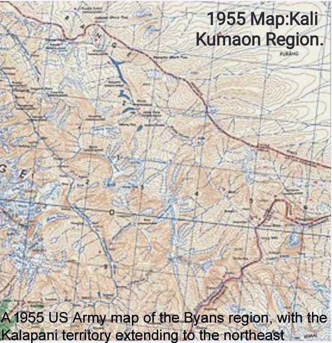
Kalapani area seemed to be under threat, Nepal too had sought Indian assistance to police Northern Areas. The US Army of 1955 reflects Kalapani territory to be part of India,
Click to enlage
Sino India Trade Agreement of 1954 mentioned that Lipulekh was a Pass/ gatewayto be used for Trade & Pilgrimage. A State Police (Armed) Post was established at Kalapani in 1965, later on an ITBP Post also came up here. Currently SSB and ITBP Posts are located here.
The 1961, China Nepal Boundary Agreement recognized Tinkar Pass as Nepal entry point, it stated that:-
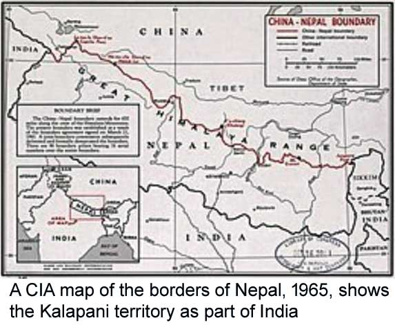
The Chinese Nepalese Boundary line starts from the Point where the Watershed between Kali River and Tinkar River meets the watershed be tributaries of Mapchu (Karnail) River on one hand and Tinker River on the other hand”. A CIA 1965 Map shows Kalapani Territory to be part of India.
Click to enlarge
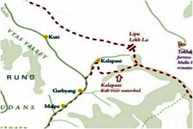
The Tri Junction between India-Nepal-China was on the dividing line ofKali Watershed and Tinker Watershed near Tinkar Pass. This is where the Boundary Pillar No:1 was placed and still continues to there.
The distance between Lipulekh to Tri Junction is approx. 5.5 Kms, most of the people have been calling Lipulekh to be the Western Tri Junction of India-Tibet-Nepal.
Click to enlarge
Post Indo China War 1962, India had closed Lipulekh Pass and the Bhyans (Bhotias) of Kumaon Region then used the Tinkar Pass on Nepal Tibet Border for their Trade with Tibet.
Local Developments Post Independence.
Despite being hilly rugged terrain the areas upto Kalapani were developed by East India Company, their main interest was Trade and since they maintained the Outpost at Kalapani (since 1865) and Tawaghat –Lipulekh had Mule Track or Bridle path. The area was developed by the Govt of India post-Independence.
Click to enlarge
The Bridle path from Kalapani to Lipulekh was constructed in 1958/1959, it had Light Girder Bridge near Nabhidang Camp (Author’s Uncle (now in his nineties) was the PWD Engineer in Charge. The Engineer who oversaw the construction of Mule Track from Jipti to Malapa was awarded the Title of Rai Bhadur Shahib.) In 1960,sanction for Motor Road from Tawaghat to Kalapani along the western bank of Kali River was accorded.
The survey for the same was done but the construction could not make much progress because of difficult terrain and lack of any worthwhile earth moving equipment, all that was available those days were explosives and manual labour.
Soon 1962 Sino Indian War happened and the project of Motor Road was shelved due to the Defence considerations. Post 1962, Indian Military presence along Indo Tibet Border was enhanced but their sustenance took place along the bridle path of British era till Kalapani.
In Dec 1991 during Premier Li Ping’s visit, India and China agreed to open up Lipulekh Pass for resuming border Trade, Nepal did not then raise any protests since the trade was envisaged to be Lipulekh. Indian Govt did not take up the construction of motorable road in this sector, despite our forward posture (late Eighties) in Eastern Ladakh.
In 1996, India and Nepal signed an Agreement on Sharing of Mahakali River.
In the year 1998, due to internal political reasons Nepal raised the issue of Kalapani Territory claiming all areas East of Lipu Gad/Kalapani River, claiming that Lipu Gad was in fact the Kali River up to its source. In 1998, another agreement was signed to resolve/settle the boundary disputes including the Kalapani dispute bilaterally.
The Dispute.
The Sugaoli Treaty (1816) only talks of the Indo -Nepal Boundary along Kali River, it doesnot talk of its branches beyond its headwaters near Gunji.
Nepal’s claim (1817) along Kuthi Yangti River till Lampiya Dhura had been rejected by the British, since they maintained Kali River originated from Kalapani Springs near Kalapani Village.
In 1865, British shifted the Border from Kalapani to the Watershed in the East and South (Kalapani Territory).
Till 1997, Nepal had never raised any territorial issues in this area. It was in 1998 because of domestic political compulsions Nepal claimed the areas South of Lipu Gad. The Nepalese were calling Lipu Gad to be Kali River up to its source up to the slopes of Lipulekh. They wanted to shift the Border about 5 kms to the West of Tri Junction to include areas up to Lipulekh.
Click to enlarge
Indian authorities produced Revenue records of 1830s to show that Kalapani was part of Pithoragarh District (earlier it was a Tehsil of Almora District), inhabitants of villages of Garbyang and Gunji had their agriculture land/pastures in the Kalapani Valley. As regards, Kuthi Valley was concerned, British produced records to say that inhabitants of Byans Valley were in fact the Zamindars. Indians also refuted the Nepalese Claim of calling Lipu Gad as Kali River.India maintained that Kali River begins only after Lipu Gad is joined by other streams in the vicinity of Kalapani.
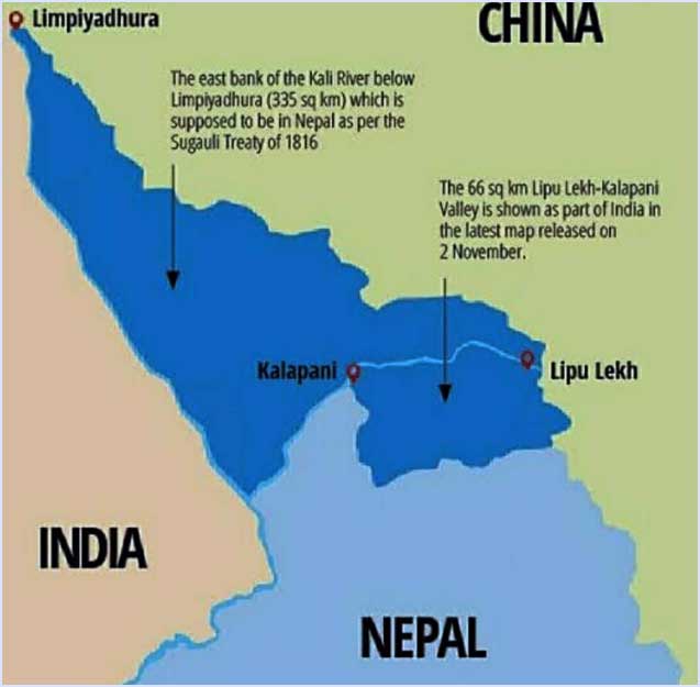
The whole area of approx 35 sqkms between Lipu Gad and the Watershed further to South was being claimed in 1998 by Nepal. This issue of “Kalapani Territory” had remained unresolved despite several rounds of talks/negotiations on the subject.
The Claim to the Kuthi Valley (Byans Region) being origin of Mahakali River lies in further West, a claim which the British had rejected around 1817 and it was in contradiction of their Claim of “Kalapani Territory”, when they were calling Lipu Gad to be Kali River.
While Nepal had earlier been claiming Kalapani Territory, it has now raised the bogey of Kuthi Yangti Valley right up to Lampiya Dhuraan measuring about 335sqkms.
Epilogue.
Kalapani Territory and the Byans/ Kuthi (Vayas) Valley have been historically part of Kali Kumaon region, the present District Pithoragarh. The Sugaoli Treaty of 1816 had been replaced by Treaty of Perpetual Peace and Friendship 1923.
Original Copy of Sugaoli Treaty is neither available with British or with Govt of Nepal. The British have abdicated their responsibilities in all their erstwhile Colonies.
Lipulekh east of Kalapani has been used by the inhabitants of Byans (Vayas) Valley from the days of East India Company Rule in India. When the trade route through Lipulekh was closed post 1962, the locals used the Tinkar Pass on Tibet- Nepal Border for their trade with Tibet. The people of Nepal and Kali Kumaon enjoy very cordial relationship, have family ties and locals very frequently cross over to either side for the ease of their movement in winters or bad weather; the Indo Nepal Border is an Open Border. In fact the Nepalese businessmen of Jhulaghat or Dharchula always got their goods from Nepal across the Nepal India Border at Mahendergarh thereafter transported them by road through India to take them across by foot over the Suspension Rope Way Bridge over Kali River at these two locations of Jhulaghat and Dharchula.
India should do all that would be required to put all Nepalese apprehensions to rest. The recent reaction of Nepal may be seen to be at the behest of China, triggered off by avoidable uncalled for statements by Indians. It must be remembered that the Road Tawaghat-Lipulekh did not come up overnight, it is immediately on the West Bank of Kali River under direct observation of Nepal. Nepal in past never objected to the construction of this Road and suddenly the much published inauguration ceremony by the Hon RM followed by certain statements got Nepal into hyper activity, a new Map is released and the required Constitutional Amendment is on the offing as our Diplomatic efforts appear to have failed.
 Please wait...

Historical perspective is very well presented. As we read the article the authenticity gets reinforced. With Nepal having taken possession by virtue of proclamation what options India can exercise now to get the land back.
1. Dialogue at the level of Heads of government – This will have feeble effect with process remaining cumbersome.
2. Move through the ICJ with historical facts. This will push back bilateral relations at least temporarily. It is here India has to choose between cordial neighbourly relations and territorial border’s importance.
3. If source of river Kali is in India, look for options to stop the flow of water into Nepal
The choice is tough but there is a need to send stern signals
so according to the sugauli treaty, it does belong to us, but the british fked the map up because they were not satisfied or had a shitty guy who did not know how to distinguish the map according to the treaty and fked the map up. You guys clearly knowing they did this yet continue to support their new map that advantages you guys instead of correcting it? another good relation treaty then signed between nepal and india which disqualifies any previous treaty signed by british was just ‘a good relationship treaty’ which does not talk about any land. have you properly read the treaty? therefore the land dispute is still on. As a respected officer i was dissapointed to see the disrespect you showed by statung ‘Nepal not being satisfied’. It shows your personality and your unprofessionalism.
it would do everyone justice if you were to reference where you got the information from so the interested parties can go and have a look from the primary source.
I like how you have done your research to published this, but remember there is always two side to the story, but then again even in your story you have mentioned british fking up the map and Nepali goverment had yet to raise an issue. which Now they have, i hope that is to your satisfaction. One of the question being raised by India was why Nepal did not raised their voice before, it could be because India never had claimed that area before in public map, or back in the days there were no internet to inform the world a new map had been made with adjustments. And as the wise people say ‘It is never to late in life to do anything’ like raising you voice when you know something wrong just happened.
Internet is magic these days, updates us within seconds of what our neighbour countries are intending.
What are the dumb Indians in North Block, betting on Nepal ? It is a bogus dubious state, whose export to India, is toilet cleaners,dishwashers and prostitutes ?
Such a nation and race, can be bought by any one.dindooohindoo
India has more than 300000 pensioners of the Indian Army, in Nepal, to whom pensions and medical and other sops, worth 2 billion USD per annum,are expended by India ! This is when there are 300 million people starving in India.This money rotates in the Nepal economy ! Y ?
Y do Indian tras, use cheap Nepali Toilet cleaners, dishwasher and prostitutes ? There are 2 crore Nepalis in India – who earn an average of Rs 1 lac per annum,which is USD 30 billion – out of which 50% is sent out of the India
Y ? When there is so much poverty and unemployment in India ?
If PRC takes over the Indian army pension bill, to Nepalis – and doubles the pension – the pensioners in Nepali, from the Indian Army, will join the PRC ! All the infantry intel and intel on military installations and forward positions – will be sold by the Nepali soldiers to the PRC !
Y willl a national of a foreign nation, serve in the Indian Army ? Is it that they are mercenaries ? There are 500 million underemployed Indians ! Are Indians a race of wimps – to use midget mercenaries in its army ?
This is 2020 – it is a high tech war – what will these Nepali illiterates do ?
It is a nation of illiterates and wimps – who care bankrupt and incapable of running a nation ! How can such a nation be a strategic partner ? Eiither India takes over Nepal with the Madhesis or just break off with the Nepali shit hole – as they will ULTIMATELY go to PRC . As time passes ,the link with India will lose – FOR SURE !
India cannot compete with the PRC, in terms of what PRC can spend on Nepal. dindooohindoo
the world revolves around migration these days incase you were not aware. We have your people in our nepal and you have our people in india. your people are earning honestly in our country and so are ours. every job is a job therefore those honest harworker should be respected not degrated. You should do your research about how nepali prostitutes came to be about, whay you find may surprise you. No female wants to work as a prostitute, do you think they went into such job role willingly? Having a good relation with your neighbour is vital these days to keep truce and peace. People with your thinking amd thoughs are the reason why war gets created. Your selfish and narrow mind is an infectious disease like virus without cure. Start by researching about why your country is lacking instead of pointing fingers at your neighbours for steallng jobs that no body wants. pfft.
You mean to say that your country do not have dishwashers, toilet cleaner and prostitutes? You disrespect a political party or a govt. that is acceptable but you disrespect a whole nation and the people living in it ny your fake allegations. Our people not only go to India but several other countries as well. And just so you know Mr. Sardana just because some people are dishwashers and toilet cleaners and prostitutes doesnt means the whole country is made up of those people. Go to sonagachi in your west bengal, bangalore red light areas and mumbai too. All those prostitutes will tell you what nationality they represent. These nepali illiterates are the ones you need at your frontiers when there is terrorism at your Kashmir. Mercenaries what you call them, those mercenaries are the ones you need the most because you dont have to take care of their children and family during or after their service. So those mercenaries are less costly and highly qualified for the job you need them. Now lets come to illiteracy, the way you expressed your views and the way I did it will explain what a literate person is like. Its people like you who spread hatred among common public you are no different than your national news reporter Arnab Goswami. I have tried to not disrespect you but my patriotic heart says Fuck You motherfucker no one can buy us or our country you piece of cunt.
Collection of material is great work. One should have his feet on the ground to start with these matters. The base is the Sugauli treaty.
Other things mentioned on the article is not concerned over the original land.
One must clearly understand that there are no treaties after Sugauli and the name of the river given in the map is wrong.
Showing 1800 documents is not the point. The point should be based only in the treaty.
Everyone can see the map prepared by the British ruler back then when They were established in India. Its still out there.
Relationship between India and Nepal is more than one can say thus then prime minister from both country under mutual understanding made an agreement about staying in to peek Chinese activities only. Truth is Indian concern over the Chinese spreading created a situation to ask the land area for peeking the Chinese. The Indian army never left the area. This continues and later and India proposed the map thereafter assuming the territories as Indian.
This paper is very accurate, historical, authentic and present real position.
Excellent