


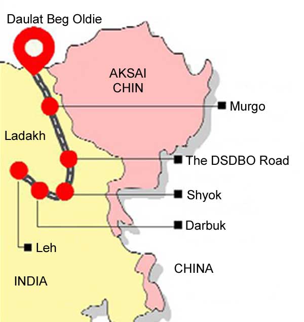
Click to enlarge
India has completed the 255-km Darbuk-Shayok-Daulat Beg Oldie (DSDBO) section of the road between Leh and Karakoram (KK) Pass, as mentioned in recent media reports. The road actually ends at DBO, not KK Pass. DBO is eight km crow flight south of KK Pass which is considerable distance in that terrain. But it is a strategically vital road because DBO is a military base on the ancient trade route connecting the Ladakh to the Tarim Basin, with Chip Chap River flowing just south of DBO. DBO lies nine km northwest of Aksai Chin which is part of J&K and under illegal occupation of China. Significantly, DBO also has the highest airstrip in the world at an altitude of 5065 metres (16,614 feet).
The DSDBO road is actually not new but large segments have had to be realigned and rebuilt. Construction of the DSDBO Road by the Border Road Organization (BRO) began 19 years ago in year 2000 under direct monitoring of the PMO and was required to be completed by 2012. However, in 2011, a CVC-instructed Chief Technical Examiner (CTE) inquiry found that the DSDBO Road had been laid on flatter terrain on the Shyok riverbed instead of on the mountainside, making it unfit for military use.
Construction of the road in or near the riverbed, contrary to approved plans, resulted in damage every summer as melting snow from the upper reaches flooded the Shyok River. During summer months from June to October, the road remained closed for up to 94 days due to rise in the water level, generally at km 99 to 105.50, 106.6, 112, 121.50, 124.32, 130.00, 138.8, and km 148 to 162.
The inquiry estimated that half of the money spent in the Rs 320 cr project, mainly for cutting 14,900 cubic metres of mountain side per kilometer stretch had been “misappropriated”. With BRO under the Ministry of Defence (MoD), it is quite obvious that the scam of some Rs 160 cr with such blatant corruption benefitted officials of both PMO and MoD. Post the inquiry, orders were issued to realign large segment of the DSDBO Road with completion deadline extended to year 2014. But this road eventually took another five years to complete.
What has been the additional cost and who is accountable for it remains unknown. As usual such scams will be kept under wraps because the bureaucrats can’t be touched and don’t the politicians share the loot? Overall, the DSDBO road has some 37 bridges built across rivers.
This road linking DBO to Leh via Karu over the Chang La Pass, dominates the area where China undertook two major intrusions in April 2013 and September 2014 in the Depsang Plains, one of them 19 km deep in area of Raki Nala while Chinese premier Li Keqiang visited India.
In September 2013, the then Defence Minister AK Anthony conceded in Parliament that China was superior in terms of border infrastructure as India was late in deciding on building roads and other capabilities near the LAC because of the impact of 1962 war, describing it as a “collective failure” of all successive governments.
Significantly, Anthony stated that besides 73 roads being constructed, 14 strategic railway lines close to border with China and Pakistan are planned, and of these 14 planned railway lines, survey had been completed for 12. Notably, development plan for border infrastructure had been approved by the Indian government even 12-15 years before Anthony made this statement. Good that the DSDBO road at least will help dominate the LAC and areas abutting Aksai Chin, Jiwan Nalla and Chip-Chap River etc.
Nothing more was heard about the 14 strategic rail-lines, till news reports of June 2018 stating that surveys were underway for four railway lines: Bilaspur-Manali-Leh railway line (498 km); Misamari-Tenga-Tawang (378 km); North Lakhimpur-Bame (Along)-Silapathar (249 km), and; Pasighat-Teju-Parsuram Kund-Rupai (227 km), and that combined cost of Rupees 2,00,000 crore of these rail lines will be footed by MoD since these lines are to facilitate troop-armament movement at “short notice”.
The schedule mentioned was: final location survey (FLS) costing more than Rs 2 lakh crore by Indian Railways to be submitted to MoD by March 2020; five years for constructing rail-lines after submission of survey reports, and; of approximate Rupees 350 crore surveys cost, MoD has already paid Rupees 150 crore to Indian Railways.
Taxing the meager defence budget for funding these railway lines is absurd and raises a stink. These rail lines are not for exclusive military use. Bulk of the time they will be used for civilian traffic including tourists. Besides, they will also be used for movement of para-military forces (PMF) and central armed police forces (CAPF). There is no reason why these rail lines should not be funded by the Indian Railways instead of the MoD.
Besides, handling of the DSDBO Road between the PMO and MoD doesn’t inspire much confidence. Not without reason General VK Singh, MoS (EAM) mentions in his autobiography that the “pipeline’ goes right up to the PMO, which is perhaps why the decision to fund these rail lines by MoD against usual norms.
The DSDBO road has been completed but going by news reports, has till now only been traversed by a motorcycle cavalcade. A military convoy has yet to test it. Of importance also is what will be the condition of the road after the next winter since of late the quality of surfacing in border roads leaves much to be desired. Next is the missing focus of border infrastructure in the northeast, particularly in Arunachal Pradesh which China claims as ‘South Tibet’.
Prime Minister Narendra Modi inaugurated the Bogibeel Bridge on Brahmputra River in December 2018, but the border infrastructure north of it remains neglected. Recall the last intrusion in Tuting area during December 2017, where Chinese had built a 1.25 km jeepable road our side of the LAC in three feet of snow and our nearest village Bishing had no road.
Going by media reports 120 Army personnel had to be rushed to the LAC with ration that could last them for 30 days. With no roads to the border and no animal transport at disposal, Army pressed into service a company of 300 porters to stock the troops. To feed the troops before the porters arrived, Army heli-dropped 100 packets of ready-to-eat meal and 30,000 packets of chocolates. There has been no improvement of border infrastructure in these areas because of small population – read small number of votes.
An important reason why India is submissive to China is because China has built nearly 5,000 km of rail network in the Tibetan plateau linking it with mainland all weather roads right up to LAC in similarly inhospitable, rugged and very high altitude terrain to sustain over 30 divisions including 5-6 rapid reaction forces in the Tibet Autonomous Region (TAR). We could take a stand briefly at Doklam because we had the communications to react there.
However, this is hardly the case particularly in Arunachal Pradesh where our troops are sitting scores of kilometers from the LAC. The net result is that we have to lump what China says or does to us; our troops can only take a stand if they at the border and can quickly mobilize.
Hopefully, the next government will focus more on border infrastructure and not bury its head in the sand like an ostrich under the belief there will be no conflict. Absence of border infrastructure will only enable China undertake ‘salami slicing’ of our territory.
 Please wait...

I have served in Darbuk, Tangse and chusul area in 1996, and I agree with the article written. We will fail and loose the battle if we don’t built up border infrastructure alongwith air strip(ALG) air efforts in Chusul area(A,B and C top) We also need to deploy some navel support (submarine) along with BMPs from mech inf to oppose Chinese aggression from Pengang Tso, which falls in India approx. 45 Km for that we again need to develop border infrastructure for logistic support.
Thank You.
You want to deploy submarines in Pangong lake? Solid 😀
The author is writing based on “Gut” feeling and not facts. Not being a technically qualified individual, he is commenting on things that he does not understand! There are solutions that are theoretically right but practically wrong. DS-DBO road was one such case. Roads are constructed over existing routes which are easy and practical. Construction by cutting mountains when a track exists is not practical. If mountains have to be cut just because it is ordained as a mountain road when a flat portion exists from where the road can travel is illogical.
It would be better if greater control is exercised over articles that are based on “gut” feeling instead of facts. If required, facts need to be checked before being put into print.
China is a devouring beast that cannot be satiated. They will only want more and more. But their weakness is that they do not have the high altitude resolve that India can maintain with better conditioned troops. They rely on their logistics, but spirit is another matter.
I liked your post about the Kashmir breakdown…it is all over whats app….Kashmir Eye opener……and I use your article on defense forums and international forums all the time. Keep up the good work.
A very good informative artice on military issues facing India needs to be studied by all right thinking people instead of flying the kite of phoney nationalism in the public domain.
Bulls Eye, as always! There is no doubt a lot of room for improvement — the biggest room of them all!
There is little assurance of stable, dependable road links surviving the monsoons and snow. Needs a lot to infuse confidence in the minds of planners and users!